|
|
|
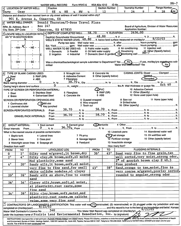
Specific Water Well Detail |
|
|
| Location Info | |||
| Owner: Donald Thurston/T-Bone Travel Plaza | Status: Constructed | ||
| Location: T26S, R28W, Sec. 12, SE NE NW | County: Gray | ||
| Directions: 901 E Avenue A, Cimarron | |||
| Latitude: 37.8073491 | Longitude: -100.3338491 | Datum NAD 27 | |
| Latitude: 37.8073706 | Longitude: -100.3342711 | Datum NAD 83 | |
| Longitude and latitude calculated by Survey from township-range-section-quarter calls. Only good to within the quarter call accuracy. | |||
| View well on interactive map | |||
| General Info | ||
| Well Depth: 58.7 ft. | Elevation: 2636 ft. | |
| Static Water Level: 48.8 ft. | Est. Yield: gpm. | |
| Comp. Date: 22-Aug-2003 | Well Use: Monitoring well/observation/piezometer | |
| DWR Applic. #: | Other ID: MW 7 | |
| Driller Info | ||
| Driller: Prairie Land Environmental Remed. | License #: 540 | |
| Scanned Form | View scan |
|
Chemical Sample Submitted?:
Water Well disinfected?: | ||
| Casing Info | ||
| Casing Type:
Casing Joints: |
Diam: in. to ft | |
| Casing height above land surface: in
Casing Weight: lbs/ft Wall thickness or gauge no.: | ||
| Screen and Perforation Info | ||
| Screen Type: | Screen Openings: | |
| Screen-perforated intervals | From: ft to ft | |
| Gravel pack intervals | From: ft to ft | |
| Grout Info | ||
| Grout used: | From: to ft | |
| Source of Possible Contamination | ||
| Source: | ||
| Direction from well: | Distance: ft | |
| Lithologic Log
(Log data entered by KGS.) | ||
| From: 0 ft. to 2 ft. | Silty sand with gravel, light brown, dry | |
| From: 2 ft. to 4 ft. | Silty clay, dark brown, soft, slightly moist, Medium plasticity, some sand | |
| From: 4 ft. to 20 ft. | Sandy silt, light brown, soft, slightly moist, very fine to fine sand, few small white caliche nodules, slightly clayey | |
| From: 20 ft. to 26 ft. | Sandy silt, light brown, soft, slightly moist, very fine to fine sand, few small white caliche nodules, slightly clayey, fine to coarse sand | |
| From: 26 ft. to 34 ft. | Clayey silt, brown, soft, slightly moist, slight plasticity, root casts, some fine sand | |
| From: 34 ft. to 39 ft. | Silty clay, brown, soft, moist, medium plasticity, root casts, small caliche veins, some very fine sand | |
| From: 39 ft. to 43 ft. | Sand very fine to fine grain, tan well sorted, very moist, strong odor, 2 inches of grayish brown clay at 40.5 feet product | |
| From: 43 ft. to 59 ft. | Sand, orange to tan, moist, fine to very coarse with gravel, poorly sorted, rounded to angular, strong odor | |