|
|
|
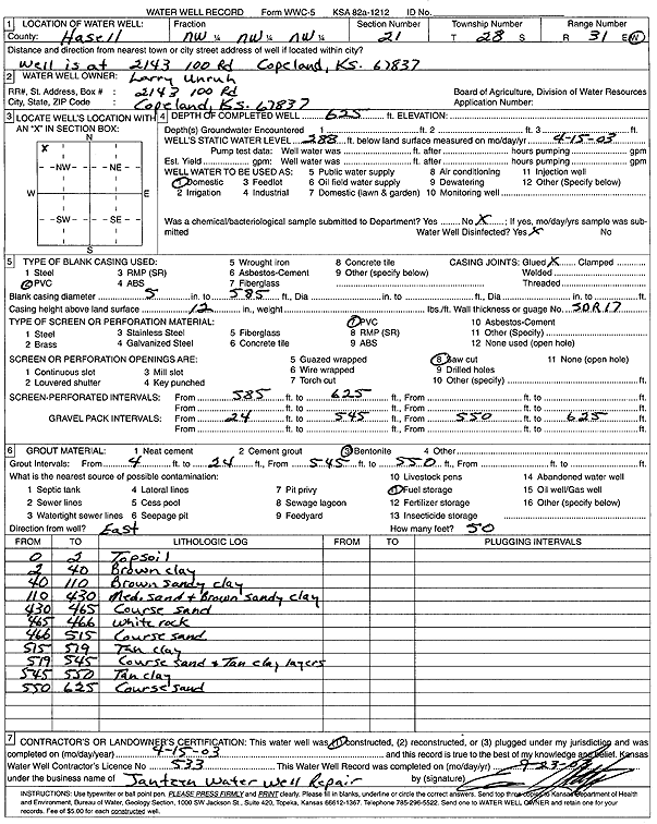
Specific Water Well Detail |
|
|
| Location Info | |||
| Owner: Unruh, Larry | Status: Constructed | ||
| Location: T28S, R31W, Sec. 21, NW NW NW | County: Haskell | ||
| Directions: 2143 100 Rd, Copeland | |||
| Latitude: 37.6046908 | Longitude: -100.7239553 | Datum NAD 27 | |
| Latitude: 37.604715 | Longitude: -100.7243918 | Datum NAD 83 | |
| Longitude and latitude calculated by Survey from township-range-section-quarter calls. Only good to within the quarter call accuracy. | |||
| View well on interactive map | |||
| General Info | ||
| Well Depth: 625 ft. | Elevation: ft. | |
| Static Water Level: 288 ft. | Est. Yield: gpm. | |
| Comp. Date: 15-Apr-2003 | Well Use: Domestic | |
| DWR Applic. #: | Other ID: | |
| Driller Info | ||
| Driller: Ed Jantzen Water Well Repair | License #: 533 | |
| Scanned Form | View scan |
|
Chemical Sample Submitted?:
Water Well disinfected?: | ||
| Casing Info | ||
| Casing Type:
Casing Joints: |
Diam: in. to ft | |
| Casing height above land surface: in
Casing Weight: lbs/ft Wall thickness or gauge no.: | ||
| Screen and Perforation Info | ||
| Screen Type: | Screen Openings: | |
| Screen-perforated intervals | From: ft to ft | |
| Gravel pack intervals | From: ft to ft | |
| Grout Info | ||
| Grout used: | From: to ft | |
| Source of Possible Contamination | ||
| Source: | ||
| Direction from well: | Distance: ft | |
| Lithologic Log
(Log data entered by KGS.) | ||
| From: 0 ft. to 2 ft. | top soil | |
| From: 2 ft. to 40 ft. | brown clay | |
| From: 40 ft. to 110 ft. | brown sandy clay | |
| From: 110 ft. to 430 ft. | medium sand and brown sandy clay | |
| From: 430 ft. to 465 ft. | coarse sand | |
| From: 465 ft. to 466 ft. | white rock | |
| From: 466 ft. to 515 ft. | coarse sand | |
| From: 515 ft. to 519 ft. | tan clay | |
| From: 519 ft. to 545 ft. | coarse sand and tan clay layers | |
| From: 545 ft. to 550 ft. | tan clay | |
| From: 550 ft. to 625 ft. | coarse sand | |