|
|
|
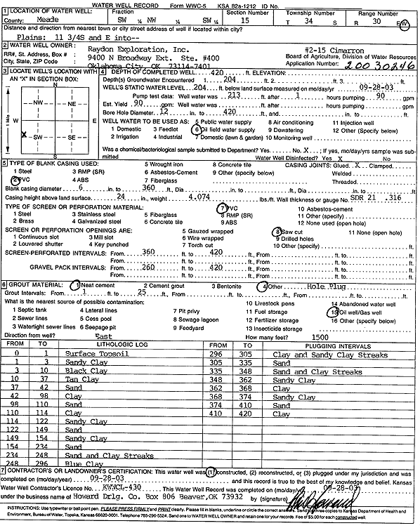
Specific Water Well Detail |
|
|
| Location Info | |||
| Owner: Raydon Exploration Co., Inc. | Status: Constructed | ||
| Location: T34S, R30W, Sec. 15, SW NW SW | County: Meade | ||
| Directions: from Plains: 11.75 mi S, E into site | |||
| Latitude: 37.0872016 | Longitude: -100.5780221 | Datum NAD 27 | |
| Latitude: 37.0872261 | Longitude: -100.5784531 | Datum NAD 83 | |
| Longitude and latitude calculated by Survey from township-range-section-quarter calls. Only good to within the quarter call accuracy. | |||
| View well on interactive map | |||
| General Info | ||
| Well Depth: 420 ft. | Elevation: ft. | |
| Static Water Level: 204 ft. | Est. Yield: 90 gpm. | |
| Comp. Date: 28-Sep-2003 | Well Use: Oil Field Water Supply | |
| DWR Applic. #: 20030246 | Other ID: Cimarron 2-15 | |
| Links | |
| No Wizard information available. | |
| View info from WIMAS Water Right Data base... | |
| Driller Info | ||
| Driller: Howard Drilling Company AG, LLC | License #: 430 | |
| Scanned Form | View scan |
|
Chemical Sample Submitted?:
Water Well disinfected?: | ||
| Casing Info | ||
| Casing Type:
Casing Joints: |
Diam: in. to ft | |
| Casing height above land surface: in
Casing Weight: lbs/ft Wall thickness or gauge no.: | ||
| Screen and Perforation Info | ||
| Screen Type: | Screen Openings: | |
| Screen-perforated intervals | From: ft to ft | |
| Gravel pack intervals | From: ft to ft | |
| Grout Info | ||
| Grout used: | From: to ft | |
| Source of Possible Contamination | ||
| Source: | ||
| Direction from well: | Distance: ft | |
| Lithologic Log
(Log data entered by KGS.) | ||
| From: 0 ft. to 1 ft. | surface top soil | |
| From: 1 ft. to 3 ft. | sandy clay | |
| From: 3 ft. to 10 ft. | black clay | |
| From: 10 ft. to 37 ft. | tan clay | |
| From: 37 ft. to 42 ft. | sand | |
| From: 42 ft. to 98 ft. | clay | |
| From: 98 ft. to 110 ft. | sand | |
| From: 110 ft. to 114 ft. | clay | |
| From: 114 ft. to 122 ft. | sandy clay | |
| From: 122 ft. to 149 ft. | sand | |
| From: 149 ft. to 154 ft. | sandy clay | |
| From: 154 ft. to 234 ft. | sand | |
| From: 234 ft. to 248 ft. | sand and clay streaks | |
| From: 248 ft. to 296 ft. | blue clay | |
| From: 296 ft. to 305 ft. | clay and sandy clay streaks | |
| From: 305 ft. to 335 ft. | sand | |
| From: 335 ft. to 348 ft. | sand and clay streaks | |
| From: 348 ft. to 362 ft. | sandy clay | |
| From: 362 ft. to 368 ft. | clay | |
| From: 368 ft. to 374 ft. | sandy clay | |
| From: 374 ft. to 410 ft. | sand | |
| From: 410 ft. to 420 ft. | clay | |