|
|
|
Specific Water Well Detail |
|
|
| Location Info | |||
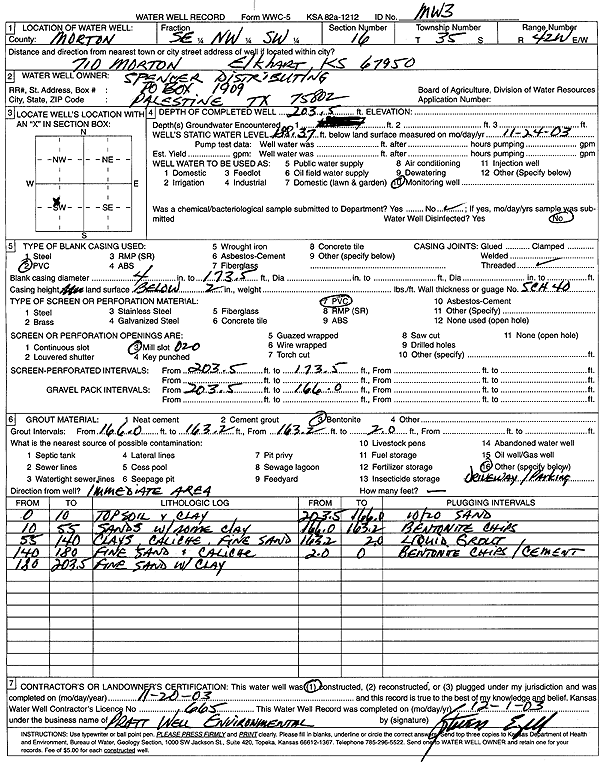
| Owner: Spencer Distributing | Status: Constructed | ||
| Location: T35S, R42W, Sec. 16, SE NW SW | County: Morton | ||
| Directions: 710 Morton, Elkhart | |||
| Latitude: 37.0005064 | Longitude: -101.8949998 | Datum NAD 27 | |
| Latitude: 37.00053 | Longitude: -101.8954441 | Datum NAD 83 | |
| Longitude and latitude calculated by Survey from township-range-section-quarter calls. Only good to within the quarter call accuracy. | |||
| View well on interactive map | |||
| General Info | ||
| Well Depth: 203.5 ft. | Elevation: ft. | |
| Static Water Level: 188.37 ft. | Est. Yield: gpm. | |
| Comp. Date: 20-Nov-2003 | Well Use: Monitoring well/observation/piezometer | |
| DWR Applic. #: | Other ID: MW 3 | |
| Driller Info | ||
| Driller: Pratt Well Service, Inc. | License #: 665 | |
| Scanned Form | View scan |
|
Chemical Sample Submitted?:
Water Well disinfected?: | ||
| Casing Info | ||
| Casing Type:
Casing Joints: |
Diam: in. to ft | |
| Casing height above land surface: in
Casing Weight: lbs/ft Wall thickness or gauge no.: | ||
| Screen and Perforation Info | ||
| Screen Type: | Screen Openings: | |
| Screen-perforated intervals | From: ft to ft | |
| Gravel pack intervals | From: ft to ft | |
| Grout Info | ||
| Grout used: | From: to ft | |
| Source of Possible Contamination | ||
| Source: | ||
| Direction from well: | Distance: ft | |
| Lithologic Log
(Log data entered by KGS.) | ||
| From: 0 ft. to 10 ft. | topsoil and clay | |
| From: 10 ft. to 55 ft. | sand with some clay | |
| From: 55 ft. to 140 ft. | clays, caliche, fine sand | |
| From: 140 ft. to 180 ft. | fine sand and caliche | |
| From: 180 ft. to 203.5 ft. | fine sand with clay | |