|
|
|
Specific Water Well Detail |
|
|
| Location Info | |||
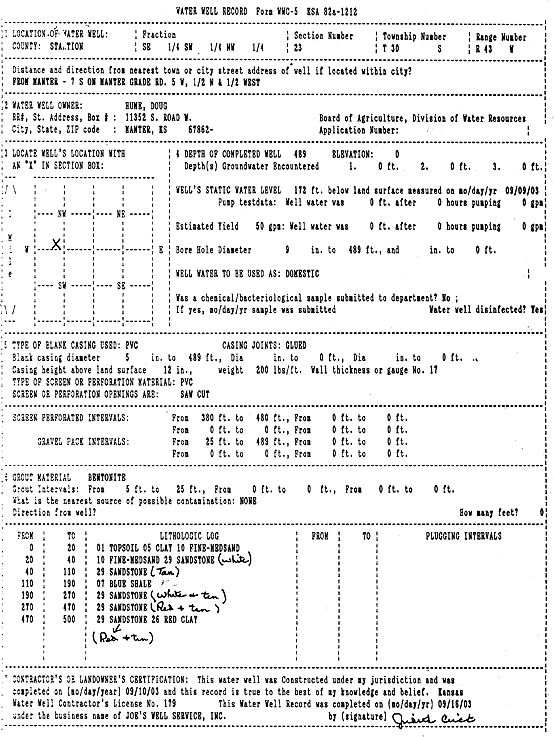
| Owner: Hume, Doug | Status: Constructed | ||
| Location: T30S, R43W, Sec. 23, SE SW NW | County: Stanton | ||
| Directions: from Manter: 7 mi S on Manter Grade Rd, 5 mi W, .5 mi N, .5 mi W | |||
| Latitude: 37.4266109 | Longitude: -101.9950666 | Datum NAD 27 | |
| Latitude: 37.4266292 | Longitude: -101.9955191 | Datum NAD 83 | |
| Longitude and latitude calculated by Survey from township-range-section-quarter calls. Only good to within the quarter call accuracy. | |||
| View well on interactive map | |||
| General Info | ||
| Well Depth: 489 ft. | Elevation: ft. | |
| Static Water Level: 172 ft. | Est. Yield: 50 gpm. | |
| Comp. Date: 10-Sep-2003 | Well Use: Domestic | |
| DWR Applic. #: | Other ID: | |
| Driller Info | ||
| Driller: Joe's Well Service, Inc. | License #: 179 | |
| Scanned Form | View scan |
|
Chemical Sample Submitted?:
Water Well disinfected?: | ||
| Casing Info | ||
| Casing Type:
Casing Joints: |
Diam: in. to ft | |
| Casing height above land surface: in
Casing Weight: lbs/ft Wall thickness or gauge no.: | ||
| Screen and Perforation Info | ||
| Screen Type: | Screen Openings: | |
| Screen-perforated intervals | From: ft to ft | |
| Gravel pack intervals | From: ft to ft | |
| Grout Info | ||
| Grout used: | From: to ft | |
| Source of Possible Contamination | ||
| Source: | ||
| Direction from well: | Distance: ft | |
| Lithologic Log
(Log data entered by KGS.) | ||
| From: 0 ft. to 20 ft. | topsoil clay fine-medium sand | |
| From: 20 ft. to 40 ft. | fine-medium sand sandstone (white) | |
| From: 40 ft. to 110 ft. | sandstone (tan) | |
| From: 110 ft. to 190 ft. | blue shale | |
| From: 190 ft. to 270 ft. | sandstone (white and tan) | |
| From: 270 ft. to 470 ft. | sandstone (red and tan) | |
| From: 470 ft. to 500 ft. | sandstone (red and tan) red clay | |