|
|
|
Specific Water Well Detail |
|
|
| Location Info | |||
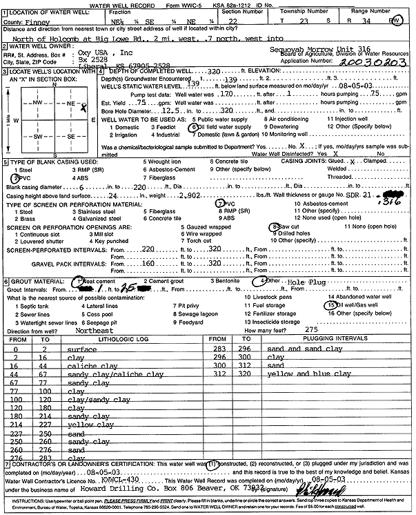
| Owner: Oxy USA, Inc. | Status: Constructed | ||
| Location: T23S, R34W, Sec. 22, NE SE NE | County: Finney | ||
| Directions: from Holcomb: N at Big Lowe Rd, 2 mi W, .7 mi N, W into address | |||
| Latitude: 38.0424515 | Longitude: -101.0300451 | Datum NAD 27 | |
| Latitude: 38.0424752 | Longitude: -101.0304887 | Datum NAD 83 | |
| Longitude and latitude calculated by Survey from township-range-section-quarter calls. Only good to within the quarter call accuracy. | |||
| View well on interactive map | |||
| General Info | ||
| Well Depth: 320 ft. | Elevation: ft. | |
| Static Water Level: 139 ft. | Est. Yield: 75 gpm. | |
| Comp. Date: 05-Aug-2003 | Well Use: Oil Field Water Supply | |
| DWR Applic. #: 20030203 | Other ID: Sequoyah Morrow Unit 316 | |
| Links | |
| No Wizard information available. | |
| View info from WIMAS Water Right Data base... | |
| Driller Info | ||
| Driller: Howard Drilling Company AG, LLC | License #: 430 | |
| Scanned Form | View scan |
|
Chemical Sample Submitted?:
Water Well disinfected?: | ||
| Casing Info | ||
| Casing Type:
Casing Joints: |
Diam: in. to ft | |
| Casing height above land surface: in
Casing Weight: lbs/ft Wall thickness or gauge no.: | ||
| Screen and Perforation Info | ||
| Screen Type: | Screen Openings: | |
| Screen-perforated intervals | From: ft to ft | |
| Gravel pack intervals | From: ft to ft | |
| Grout Info | ||
| Grout used: | From: to ft | |
| Source of Possible Contamination | ||
| Source: | ||
| Direction from well: | Distance: ft | |
| Lithologic Log
(Log data entered by KGS.) | ||
| From: 0 ft. to 2 ft. | surface | |
| From: 2 ft. to 16 ft. | clay | |
| From: 16 ft. to 44 ft. | caliche clay | |
| From: 44 ft. to 67 ft. | sandy clay caliche clay | |
| From: 67 ft. to 77 ft. | sandy clay | |
| From: 77 ft. to 100 ft. | clay | |
| From: 100 ft. to 120 ft. | clay/sandy clay | |
| From: 120 ft. to 180 ft. | clay | |
| From: 180 ft. to 214 ft. | sandy clay | |
| From: 214 ft. to 227 ft. | yellow clay | |
| From: 227 ft. to 250 ft. | sand | |
| From: 250 ft. to 260 ft. | sandy clay | |
| From: 260 ft. to 276 ft. | sand | |
| From: 276 ft. to 283 ft. | clay | |
| From: 283 ft. to 296 ft. | sand and sand clay | |
| From: 296 ft. to 300 ft. | clay | |
| From: 300 ft. to 312 ft. | sand | |
| From: 312 ft. to 320 ft. | yellow and blue clay | |