|
|
|
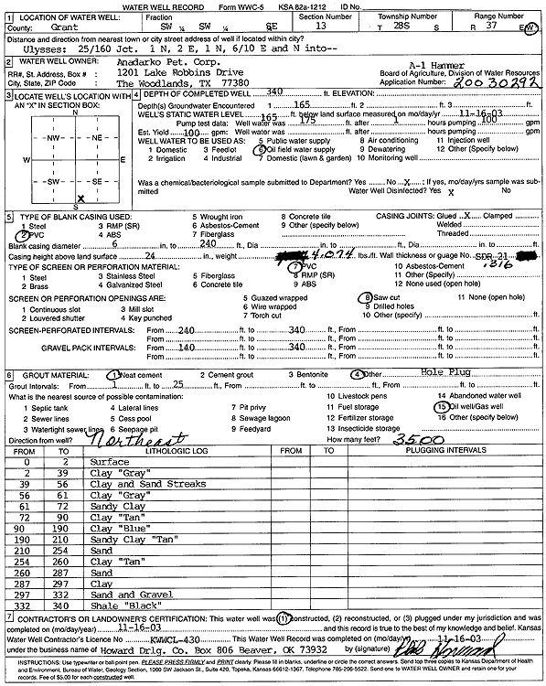
Specific Water Well Detail |
|
|
| Location Info | |||
| Owner: Anadarko Petroleum Corp. | Status: Constructed | ||
| Location: T28S, R37W, Sec. 13, SW SW SE | County: Grant | ||
| Directions: from Ulysses: 1 mi N of 25/160 Jct, 2 mi E, .6 mi E, N into address | |||
| Latitude: 37.606393 | Longitude: -101.316496 | Datum NAD 27 | |
| Latitude: 37.6064135 | Longitude: -101.316944 | Datum NAD 83 | |
| Longitude and latitude calculated by Survey from township-range-section-quarter calls. Only good to within the quarter call accuracy. | |||
| View well on interactive map | |||
| General Info | ||
| Well Depth: 340 ft. | Elevation: ft. | |
| Static Water Level: 165 ft. | Est. Yield: 100 gpm. | |
| Comp. Date: 16-Nov-2003 | Well Use: Oil Field Water Supply | |
| DWR Applic. #: 20030292 | Other ID: Hammer A 1 | |
| Links | |
| No Wizard information available. | |
| View info from WIMAS Water Right Data base... | |
| Driller Info | ||
| Driller: Howard Drilling Company AG, LLC | License #: 430 | |
| Scanned Form | View scan |
|
Chemical Sample Submitted?:
Water Well disinfected?: | ||
| Casing Info | ||
| Casing Type:
Casing Joints: |
Diam: in. to ft | |
| Casing height above land surface: in
Casing Weight: lbs/ft Wall thickness or gauge no.: | ||
| Screen and Perforation Info | ||
| Screen Type: | Screen Openings: | |
| Screen-perforated intervals | From: ft to ft | |
| Gravel pack intervals | From: ft to ft | |
| Grout Info | ||
| Grout used: | From: to ft | |
| Source of Possible Contamination | ||
| Source: | ||
| Direction from well: | Distance: ft | |
| Lithologic Log
(Log data entered by KGS.) | ||
| From: 0 ft. to 2 ft. | surface | |
| From: 2 ft. to 39 ft. | clay, gray | |
| From: 39 ft. to 56 ft. | clay and sand streaks | |
| From: 56 ft. to 61 ft. | clay, gray | |
| From: 61 ft. to 72 ft. | sandy clay | |
| From: 72 ft. to 90 ft. | clay, tan | |
| From: 90 ft. to 190 ft. | clay, blue | |
| From: 190 ft. to 210 ft. | sandy clay, tan | |
| From: 210 ft. to 254 ft. | sand | |
| From: 254 ft. to 260 ft. | clay, tan | |
| From: 260 ft. to 287 ft. | sand | |
| From: 287 ft. to 297 ft. | clay | |
| From: 297 ft. to 332 ft. | sand and gravel | |
| From: 332 ft. to 340 ft. | shale, black | |