|
|
|
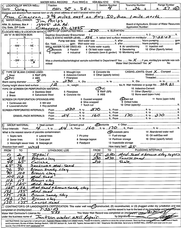
Specific Water Well Detail |
|
|
| Location Info | |||
| Owner: Phelps, Jim | Status: Constructed | ||
| Location: T26S, R27W, Sec. 4, NW SE SE | County: Gray | ||
| Directions: from Cimarron: 3.75 mi E on Hwy 50, 1 mi N | |||
| Latitude: 37.8131848 | Longitude: -100.2727716 | Datum NAD 27 | |
| Latitude: 37.813206 | Longitude: -100.2731915 | Datum NAD 83 | |
| Longitude and latitude calculated by Survey from township-range-section-quarter calls. Only good to within the quarter call accuracy. | |||
| View well on interactive map | |||
| General Info | ||
| Well Depth: 270 ft. | Elevation: ft. | |
| Static Water Level: 134 ft. | Est. Yield: gpm. | |
| Comp. Date: 22-Jul-2003 | Well Use: Domestic | |
| DWR Applic. #: | Other ID: | |
| Driller Info | ||
| Driller: Ed Jantzen Water Well Repair | License #: 533 | |
| Scanned Form | View scan |
|
Chemical Sample Submitted?:
Water Well disinfected?: | ||
| Casing Info | ||
| Casing Type:
Casing Joints: |
Diam: in. to ft | |
| Casing height above land surface: in
Casing Weight: lbs/ft Wall thickness or gauge no.: | ||
| Screen and Perforation Info | ||
| Screen Type: | Screen Openings: | |
| Screen-perforated intervals | From: ft to ft | |
| Gravel pack intervals | From: ft to ft | |
| Grout Info | ||
| Grout used: | From: to ft | |
| Source of Possible Contamination | ||
| Source: | ||
| Direction from well: | Distance: ft | |
| Lithologic Log
(Log data entered by KGS.) | ||
| From: 0 ft. to 2 ft. | Topsoil | |
| From: 2 ft. to 48 ft. | Brown clay | |
| From: 48 ft. to 65 ft. | Caliche | |
| From: 65 ft. to 76 ft. | Sandrock and medium sand | |
| From: 76 ft. to 90 ft. | Brown sandy clay | |
| From: 90 ft. to 100 ft. | Brown clay | |
| From: 100 ft. to 112 ft. | Medium sand | |
| From: 112 ft. to 117 ft. | Brown clay | |
| From: 117 ft. to 125 ft. | Medium sand | |
| From: 125 ft. to 132 ft. | Medium sand and brown sandy clay | |
| From: 132 ft. to 135 ft. | Medium Sand | |
| From: 135 ft. to 142 ft. | Brown sandy clay | |
| From: 142 ft. to 170 ft. | Brown clay | |
| From: 170 ft. to 175 ft. | Coarse sand | |
| From: 175 ft. to 230 ft. | Medium sand and brown clay layers | |
| From: 230 ft. to 270 ft. | Coarse sand | |
| From: 270 ft. to ft. | Shale | |