|
|
|
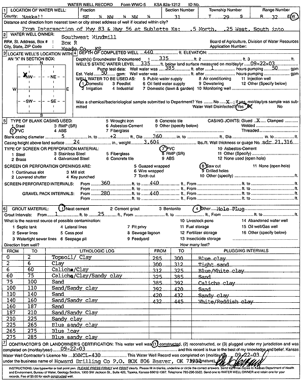
Specific Water Well Detail |
|
|
| Location Info | |||
| Owner: Southwest Windmill | Status: Constructed | ||
| Location: T29S, R32W, Sec. 31, SE NW NW | County: Haskell | ||
| Directions: from Sublette: .5 mi N of intersection of Hwy 83 and Hwy 56, .25 mi W, S into address | |||
| Latitude: 37.4867611 | Longitude: -100.8672247 | Datum NAD 27 | |
| Latitude: 37.4867857 | Longitude: -100.867666 | Datum NAD 83 | |
| Longitude and latitude calculated by Survey from township-range-section-quarter calls. Only good to within the quarter call accuracy. | |||
| View well on interactive map | |||
| General Info | ||
| Well Depth: 440 ft. | Elevation: ft. | |
| Static Water Level: 335 ft. | Est. Yield: 50 gpm. | |
| Comp. Date: 22-Sep-2003 | Well Use: Domestic | |
| DWR Applic. #: | Other ID: | |
| Driller Info | ||
| Driller: Howard Drilling Company AG, LLC | License #: 430 | |
| Scanned Form | View scan |
|
Chemical Sample Submitted?:
Water Well disinfected?: | ||
| Casing Info | ||
| Casing Type:
Casing Joints: |
Diam: in. to ft | |
| Casing height above land surface: in
Casing Weight: lbs/ft Wall thickness or gauge no.: | ||
| Screen and Perforation Info | ||
| Screen Type: | Screen Openings: | |
| Screen-perforated intervals | From: ft to ft | |
| Gravel pack intervals | From: ft to ft | |
| Grout Info | ||
| Grout used: | From: to ft | |
| Source of Possible Contamination | ||
| Source: | ||
| Direction from well: | Distance: ft | |
| Lithologic Log
(Log data entered by KGS.) | ||
| From: 0 ft. to 2 ft. | topsoil/clay | |
| From: 2 ft. to 6 ft. | clay | |
| From: 6 ft. to 60 ft. | caliche/clay | |
| From: 60 ft. to 75 ft. | caliche/clay/sandy clay | |
| From: 75 ft. to 100 ft. | sand | |
| From: 100 ft. to 110 ft. | sand/sandy clay | |
| From: 110 ft. to 140 ft. | sand | |
| From: 140 ft. to 160 ft. | sand/sandy clay | |
| From: 160 ft. to 187 ft. | sand | |
| From: 187 ft. to 210 ft. | sand/sandy clay | |
| From: 210 ft. to 225 ft. | sandy clay | |
| From: 225 ft. to 265 ft. | blue sandy clay | |
| From: 265 ft. to 275 ft. | blue clay | |
| From: 275 ft. to 285 ft. | blue sandy clay | |
| From: 285 ft. to 300 ft. | blue clay | |
| From: 300 ft. to 312 ft. | tight sand | |
| From: 312 ft. to 325 ft. | blue/white clay | |
| From: 325 ft. to 385 ft. | sand | |
| From: 385 ft. to 392 ft. | caliche clay | |
| From: 392 ft. to 420 ft. | sand | |
| From: 420 ft. to 432 ft. | sandy clay | |
| From: 432 ft. to 445 ft. | white/reddish clay | |