|
|
|
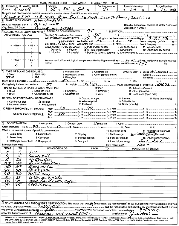
Specific Water Well Detail |
|
|
| Location Info | |||
| Owner: Vonfeldt, Alan | Status: Constructed | ||
| Location: T14S, R13W, Sec. 31, SE SW SW | County: Russell | ||
| Directions: from Russell and I-70: 4.5 mi S, 2 mi E, .5 mi S, E into site | |||
| Latitude: 38.7847497 | Longitude: -98.8141216 | Datum NAD 27 | |
| Latitude: 38.7847611 | Longitude: -98.8144819 | Datum NAD 83 | |
| Longitude and latitude calculated by Survey from township-range-section-quarter calls. Only good to within the quarter call accuracy. | |||
| View well on interactive map | |||
| General Info | ||
| Well Depth: 95 ft. | Elevation: ft. | |
| Static Water Level: 35 ft. | Est. Yield: 100 gpm. | |
| Comp. Date: 24-Sep-2003 | Well Use: Oil Field Water Supply | |
| DWR Applic. #: | Other ID: | |
| Driller Info | ||
| Driller: Jack Goodman Water Well Drilling | License #: 660 | |
| Scanned Form | View scan |
|
Chemical Sample Submitted?:
Water Well disinfected?: | ||
| Casing Info | ||
| Casing Type:
Casing Joints: |
Diam: in. to ft | |
| Casing height above land surface: in
Casing Weight: lbs/ft Wall thickness or gauge no.: | ||
| Screen and Perforation Info | ||
| Screen Type: | Screen Openings: | |
| Screen-perforated intervals | From: ft to ft | |
| Gravel pack intervals | From: ft to ft | |
| Grout Info | ||
| Grout used: | From: to ft | |
| Source of Possible Contamination | ||
| Source: | ||
| Direction from well: | Distance: ft | |
| Lithologic Log
(Log data entered by KGS.) | ||
| From: 0 ft. to 2 ft. | soil | |
| From: 2 ft. to 5 ft. | sandy soil | |
| From: 5 ft. to 35 ft. | yellow clay | |
| From: 35 ft. to 40 ft. | red and white clay | |
| From: 40 ft. to 60 ft. | black shale | |
| From: 60 ft. to 70 ft. | blue and white clay | |
| From: 70 ft. to 80 ft. | white clay | |
| From: 80 ft. to 85 ft. | white sandy shale | |
| From: 85 ft. to 90 ft. | medium sand, white, soft | |
| From: 90 ft. to 95 ft. | red shale | |