|
|
|
Specific Water Well Detail |
|
|
| Location Info | |||
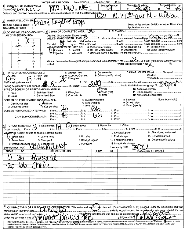
| Owner: Dopps, Brian and Daydree | Status: Constructed | ||
| Location: T30S, R4W, Sec. 9, NW NW NE | County: Sumner | ||
| Directions: 1621 W 140th Ave N, Milton | |||
| Latitude: 37.4580905 | Longitude: -97.7593474 | Datum NAD 27 | |
| Latitude: 37.4581095 | Longitude: -97.759677 | Datum NAD 83 | |
| Longitude and latitude calculated by Survey from township-range-section-quarter calls. Only good to within the quarter call accuracy. | |||
| View well on interactive map | |||
| General Info | ||
| Well Depth: 66 ft. | Elevation: ft. | |
| Static Water Level: 18 ft. | Est. Yield: 18 gpm. | |
| Comp. Date: 16-Sep-2003 | Well Use: Domestic | |
| DWR Applic. #: | Other ID: | |
| Driller Info | ||
| Driller: Jerome Weninger Drilling, Inc. | License #: 318 | |
| Scanned Form | View scan |
|
Chemical Sample Submitted?:
Water Well disinfected?: | ||
| Casing Info | ||
| Casing Type:
Casing Joints: |
Diam: in. to ft | |
| Casing height above land surface: in
Casing Weight: lbs/ft Wall thickness or gauge no.: | ||
| Screen and Perforation Info | ||
| Screen Type: | Screen Openings: | |
| Screen-perforated intervals | From: ft to ft | |
| Gravel pack intervals | From: ft to ft | |
| Grout Info | ||
| Grout used: | From: to ft | |
| Source of Possible Contamination | ||
| Source: | ||
| Direction from well: | Distance: ft | |
| Lithologic Log
(Log data entered by KGS.) | ||
| From: 0 ft. to 26 ft. | fine sand | |
| From: 26 ft. to 66 ft. | shale | |