|
|
|
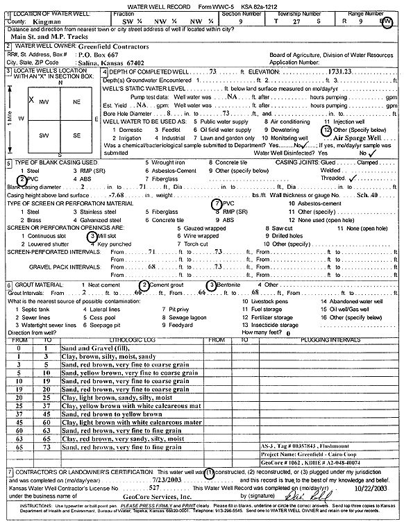
Specific Water Well Detail |
|
|
| Location Info | |||
| Owner: Greenfield Contractors | Status: Constructed | ||
| Location: T27S, R9W, Sec. 9, SW NW NW | County: Kingman | ||
| Directions: Main St and M.P. Tracks | |||
| Latitude: 37.7150776 | Longitude: -98.3178192 | Datum NAD 27 | |
| Latitude: 37.7150945 | Longitude: -98.3181682 | Datum NAD 83 | |
| Longitude and latitude calculated by Survey from township-range-section-quarter calls. Only good to within the quarter call accuracy. | |||
| View well on interactive map | |||
| General Info | ||
| Well Depth: 73 ft. | Elevation: 1731.23 ft. | |
| Static Water Level: ft. | Est. Yield: gpm. | |
| Comp. Date: 23-Jul-2003 | Well Use: Environmental Remediation, Air Sparge | |
| DWR Applic. #: | Other ID: AS 3 | |
| Driller Info | ||
| Driller: GeoCore Services Inc. | License #: 527 | |
| Scanned Form | View scan |
|
Chemical Sample Submitted?:
Water Well disinfected?: | ||
| Casing Info | ||
| Casing Type:
Casing Joints: |
Diam: in. to ft | |
| Casing height above land surface: in
Casing Weight: lbs/ft Wall thickness or gauge no.: | ||
| Screen and Perforation Info | ||
| Screen Type: | Screen Openings: | |
| Screen-perforated intervals | From: ft to ft | |
| Gravel pack intervals | From: ft to ft | |
| Grout Info | ||
| Grout used: | From: to ft | |
| Source of Possible Contamination | ||
| Source: | ||
| Direction from well: | Distance: ft | |
| Lithologic Log
(Log data entered by KGS.) | ||
| From: 0 ft. to 1 ft. | sand and gravel (fill) | |
| From: 1 ft. to 3 ft. | clay, brown, silty, moist, sandy | |
| From: 3 ft. to 5 ft. | very fine to coarse sand, red brown | |
| From: 5 ft. to 10 ft. | very fine to coarse sand, yellow brown | |
| From: 10 ft. to 19 ft. | very fine to coarse sand, red brown | |
| From: 19 ft. to 20 ft. | very fine to coarse sand, red brown | |
| From: 20 ft. to 25 ft. | clay, light brown, sandy, silty, moist | |
| From: 25 ft. to 37 ft. | clay, yellow brown, with white calcareous material | |
| From: 37 ft. to 45 ft. | sand, red brown to yellow brown | |
| From: 45 ft. to 60 ft. | clay, light brown, with white calcareous material | |
| From: 60 ft. to 63 ft. | very fine to fine sand, red brown | |
| From: 63 ft. to 65 ft. | clay, red brown, very sandy, silty, moist | |
| From: 65 ft. to 73 ft. | very fine to fine sand, red brown | |