|
|
|
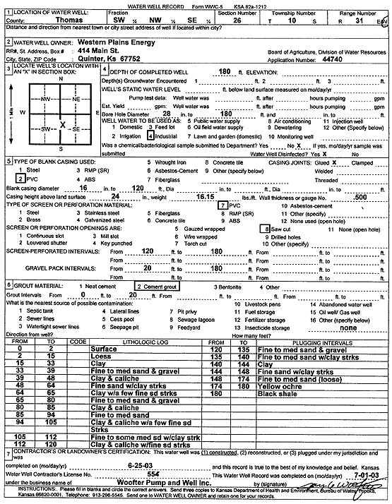
Specific Water Well Detail |
|
|
| Location Info | |||
| Owner: Western Plains Energy | Status: Constructed | ||
| Location: T10S, R31W, Sec. 26, SW NW SE | County: Thomas | ||
| Directions: | |||
| Latitude: 39.1524134 | Longitude: -100.7475676 | Datum NAD 27 | |
| Latitude: 39.1524211 | Longitude: -100.7479911 | Datum NAD 83 | |
| Longitude and latitude calculated by Survey from township-range-section-quarter calls. Only good to within the quarter call accuracy. | |||
| View well on interactive map | |||
| General Info | ||
| Well Depth: 180 ft. | Elevation: ft. | |
| Static Water Level: ft. | Est. Yield: gpm. | |
| Comp. Date: 25-Jun-2003 | Well Use: Industrial | |
| DWR Applic. #: 44740 | Other ID: | |
| Links | |
| No Wizard information available. | |
| View info from WIMAS Water Right Data base... | |
| Driller Info | ||
| Driller: Jay C. Woofter Pump & Well, Inc. | License #: 554 | |
| Scanned Form | View scan |
|
Chemical Sample Submitted?:
Water Well disinfected?: | ||
| Casing Info | ||
| Casing Type:
Casing Joints: |
Diam: in. to ft | |
| Casing height above land surface: in
Casing Weight: lbs/ft Wall thickness or gauge no.: | ||
| Screen and Perforation Info | ||
| Screen Type: | Screen Openings: | |
| Screen-perforated intervals | From: ft to ft | |
| Gravel pack intervals | From: ft to ft | |
| Grout Info | ||
| Grout used: | From: to ft | |
| Source of Possible Contamination | ||
| Source: | ||
| Direction from well: | Distance: ft | |
| Lithologic Log
(Log data entered by KGS.) | ||
| From: 0 ft. to 2 ft. | surface | |
| From: 2 ft. to 15 ft. | loess | |
| From: 15 ft. to 33 ft. | clay | |
| From: 33 ft. to 39 ft. | fine to medium sand and gravel | |
| From: 39 ft. to 48 ft. | clay and caliche | |
| From: 48 ft. to 64 ft. | fine sand with clay streaks | |
| From: 64 ft. to 65 ft. | clay with a few fine sand streaks | |
| From: 65 ft. to 80 ft. | fine to medium sand and gravel | |
| From: 80 ft. to 85 ft. | clay and caliche | |
| From: 85 ft. to 94 ft. | fine to medium sand | |
| From: 94 ft. to 105 ft. | clay and caliche with a few fine sand streaks | |
| From: 105 ft. to 112 ft. | fine to some medium sand with clay streaks | |
| From: 112 ft. to 120 ft. | clay and caliche with fine sand streaks | |
| From: 120 ft. to 135 ft. | fine to medium sand and gravel | |
| From: 135 ft. to 140 ft. | fine to medium sand with clay streaks | |
| From: 140 ft. to 144 ft. | clay | |
| From: 144 ft. to 148 ft. | fine sand with clay streaks | |
| From: 148 ft. to 174 ft. | fine to medium sand, loose | |
| From: 174 ft. to 180 ft. | yellow ochre | |
| From: 180 ft. to ft. | black shale | |