|
|
|
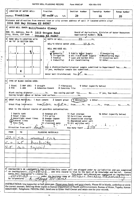
Specific Water Well Detail |
|
|
| Location Info | |||
| Owner: Clancy, Bill and Connie | Status: Plugged | ||
| Location: T16S, R20E, Sec. 29, E2 SW | County: Franklin | ||
| Directions: 3166 K-68 Hwy, Ottawa | |||
| Latitude: 38.6265093 | Longitude: -95.2230265 | Datum NAD 27 | |
| Latitude: 38.6265204 | Longitude: -95.2232768 | Datum NAD 83 | |
| Longitude and latitude calculated by Survey from township-range-section-quarter calls. Only good to within the quarter call accuracy. | |||
| View well on interactive map | |||
| General Info | ||
| Well Depth: 22 ft. | Elevation: ft. | |
| Static Water Level: 17.5 ft. | Est. Yield: gpm. | |
| Comp. Date: 14-Oct-2003 | Well Use: (unstated)/abandoned | |
| DWR Applic. #: | Other ID: | |
| Driller Info | ||
| Driller: McClure Backhoe Excavating | License #: | |
| Scanned Form | View scan |
| Casing Info | ||
|
Casing Type:
Diam: in. Casing height above land surface: in | ||
| Grout Info | ||
| Grout used: | From: to ft | |
| Source of Possible Contamination | ||
| Source: | ||
| Direction from well: | Distance: ft | |