|
|
|
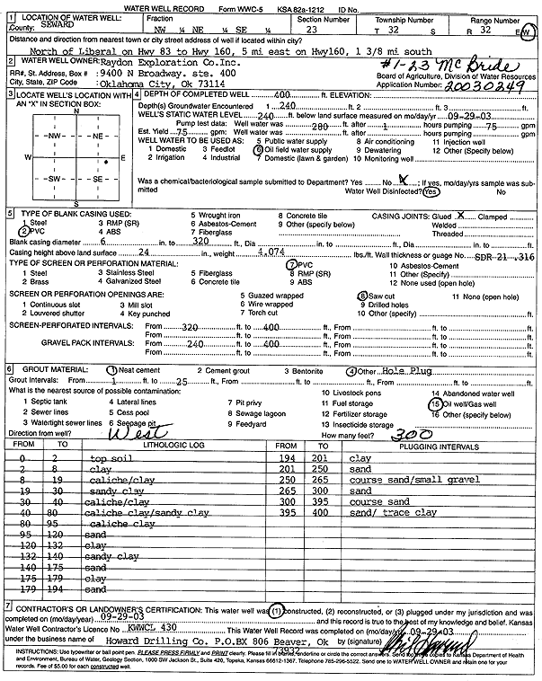
Specific Water Well Detail |
|
|
| Location Info | |||
| Owner: Raydon Exploration Co., Inc. | Status: Constructed | ||
| Location: T32S, R32W, Sec. 23, NW NE SE | County: Seward | ||
| Directions: from Liberal: N on Hwy 83, 5 mi E on Hwy 160, 1.38 mi S | |||
| Latitude: 37.2488469 | Longitude: -100.7643316 | Datum NAD 27 | |
| Latitude: 37.2488668 | Longitude: -100.7647664 | Datum NAD 83 | |
| Longitude and latitude calculated by Survey from township-range-section-quarter calls. Only good to within the quarter call accuracy. | |||
| View well on interactive map | |||
| General Info | ||
| Well Depth: 400 ft. | Elevation: ft. | |
| Static Water Level: 240 ft. | Est. Yield: 75 gpm. | |
| Comp. Date: 29-Sep-2003 | Well Use: Oil Field Water Supply | |
| DWR Applic. #: 20030249 | Other ID: McBride 1-23 | |
| Links | |
| No Wizard information available. | |
| View info from WIMAS Water Right Data base... | |
| Driller Info | ||
| Driller: Howard Drilling Company AG, LLC | License #: 430 | |
| Scanned Form | View scan |
|
Chemical Sample Submitted?:
Water Well disinfected?: | ||
| Casing Info | ||
| Casing Type:
Casing Joints: |
Diam: in. to ft | |
| Casing height above land surface: in
Casing Weight: lbs/ft Wall thickness or gauge no.: | ||
| Screen and Perforation Info | ||
| Screen Type: | Screen Openings: | |
| Screen-perforated intervals | From: ft to ft | |
| Gravel pack intervals | From: ft to ft | |
| Grout Info | ||
| Grout used: | From: to ft | |
| Source of Possible Contamination | ||
| Source: | ||
| Direction from well: | Distance: ft | |
| Lithologic Log
(Log data entered by KGS.) | ||
| From: 0 ft. to 2 ft. | top soil | |
| From: 2 ft. to 8 ft. | clay | |
| From: 8 ft. to 19 ft. | caliche/clay | |
| From: 19 ft. to 30 ft. | sandy clay | |
| From: 30 ft. to 40 ft. | caliche/clay | |
| From: 40 ft. to 80 ft. | caliche clay/sandy clay | |
| From: 80 ft. to 95 ft. | caliche clay | |
| From: 95 ft. to 120 ft. | sand | |
| From: 120 ft. to 132 ft. | clay | |
| From: 132 ft. to 140 ft. | sandy clay | |
| From: 140 ft. to 175 ft. | sand | |
| From: 175 ft. to 179 ft. | clay | |
| From: 179 ft. to 194 ft. | sand | |
| From: 194 ft. to 201 ft. | clay | |
| From: 201 ft. to 250 ft. | sand | |
| From: 250 ft. to 265 ft. | coarse sand/small gravel | |
| From: 265 ft. to 300 ft. | sand | |
| From: 300 ft. to 395 ft. | coarse sand | |
| From: 395 ft. to 400 ft. | sand/trace clay | |