|
|
|
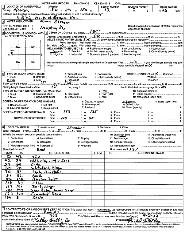
Specific Water Well Detail |
|
|
| Location Info | |||
| Owner: Strayey, Norman | Status: Constructed | ||
| Location: T2S, R25W, Sec. 12, SW SW NW | County: Norton | ||
| Directions: from Reager: 4.75 mi N | |||
| Latitude: 39.8939425 | Longitude: -100.0933904 | Datum NAD 27 | |
| Latitude: 39.8939479 | Longitude: -100.0938003 | Datum NAD 83 | |
| Longitude and latitude calculated by Survey from township-range-section-quarter calls. Only good to within the quarter call accuracy. | |||
| View well on interactive map | |||
| General Info | ||
| Well Depth: 195 ft. | Elevation: ft. | |
| Static Water Level: 137 ft. | Est. Yield: 10 gpm. | |
| Comp. Date: 02-Sep-2003 | Well Use: Domestic | |
| DWR Applic. #: | Other ID: | |
| Driller Info | ||
| Driller: Richard O. Kelley Drilling Co. | License #: 398 | |
| Scanned Form | View scan |
|
Chemical Sample Submitted?:
Water Well disinfected?: | ||
| Casing Info | ||
| Casing Type:
Casing Joints: |
Diam: in. to ft | |
| Casing height above land surface: in
Casing Weight: lbs/ft Wall thickness or gauge no.: | ||
| Screen and Perforation Info | ||
| Screen Type: | Screen Openings: | |
| Screen-perforated intervals | From: ft to ft | |
| Gravel pack intervals | From: ft to ft | |
| Grout Info | ||
| Grout used: | From: to ft | |
| Source of Possible Contamination | ||
| Source: | ||
| Direction from well: | Distance: ft | |
| Lithologic Log
(Log data entered by KGS.) | ||
| From: 0 ft. to 42 ft. | top | |
| From: 42 ft. to 54 ft. | white clay, little sand | |
| From: 54 ft. to 60 ft. | clay | |
| From: 60 ft. to 70 ft. | white sandy clay | |
| From: 70 ft. to 81 ft. | sandy limestone | |
| From: 81 ft. to 82 ft. | rock | |
| From: 82 ft. to 108 ft. | limestone soft | |
| From: 108 ft. to 117 ft. | clay | |
| From: 118 ft. to 140 ft. | sandy clay | |
| From: 140 ft. to 173 ft. | sand and clay more sand | |
| From: 173 ft. to 194 ft. | cemented sand | |
| From: 194 ft. to ft. | shale | |