|
|
|
Specific Water Well Detail |
|
|
| Location Info | |||
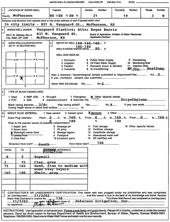
| Owner: Vanguard Plastics/Roger Burris | Status: Plugged | ||
| Location: T19S, R3W, Sec. 21, NE SE SW | County: McPherson | ||
| Directions: 831 N Vanguard St, McPherson (3-160' bores, 2-180' bores) | |||
| Latitude: 38.3793872 | Longitude: -97.6585574 | Datum NAD 27 | |
| Latitude: 38.3793953 | Longitude: -97.6588769 | Datum NAD 83 | |
| Longitude and latitude calculated by Survey from township-range-section-quarter calls. Only good to within the quarter call accuracy. | |||
| View well on interactive map | |||
| General Info | ||
| Well Depth: 160 ft. | Elevation: ft. | |
| Static Water Level: 80 ft. | Est. Yield: gpm. | |
| Comp. Date: 03-Nov-2003 | Well Use: Heat Pump (Closed Loop/Disposal), Geothermal | |
| DWR Applic. #: | Other ID: | |
| Driller Info | ||
| Driller: Michael Peterson Irrigation, Inc. | License #: 138 | |
| Scanned Form | View scan |
| Casing Info | ||
|
Casing Type:
Diam: in. Casing height above land surface: in | ||
| Grout Info | ||
| Grout used: | From: to ft | |
| Source of Possible Contamination | ||
| Source: | ||
| Direction from well: | Distance: ft | |