|
|
|
Specific Water Well Detail |
|
|
| Location Info | |||
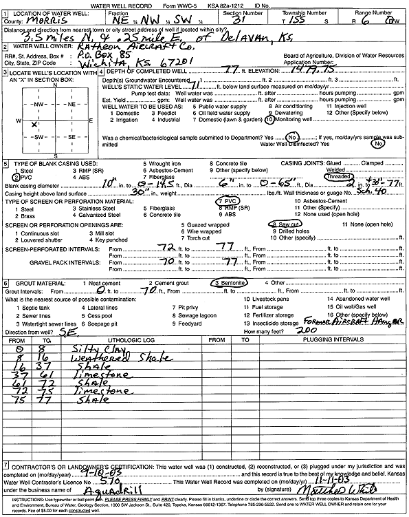
| Owner: Raytheon Aircraft Co. | Status: Constructed | ||
| Location: T15S, R6E, Sec. 31, NE NW SW | County: Morris | ||
| Directions: from Delavan: 3.5 mi N, .25 mi E | |||
| Latitude: 38.7023149 | Longitude: -96.8125313 | Datum NAD 27 | |
| Latitude: 38.7023218 | Longitude: -96.8128196 | Datum NAD 83 | |
| Longitude and latitude calculated by Survey from township-range-section-quarter calls. Only good to within the quarter call accuracy. | |||
| View well on interactive map | |||
| General Info | ||
| Well Depth: 77 ft. | Elevation: 1479.75 ft. | |
| Static Water Level: 71 ft. | Est. Yield: gpm. | |
| Comp. Date: 10-Sep-2003 | Well Use: Monitoring well/observation/piezometer | |
| DWR Applic. #: | Other ID: | |
| Driller Info | ||
| Driller: Aquadrill, Inc. | License #: 570 | |
| Scanned Form | View scan |
|
Chemical Sample Submitted?:
Water Well disinfected?: | ||
| Casing Info | ||
| Casing Type:
Casing Joints: |
Diam: in. to ft | |
| Casing height above land surface: in
Casing Weight: lbs/ft Wall thickness or gauge no.: | ||
| Screen and Perforation Info | ||
| Screen Type: | Screen Openings: | |
| Screen-perforated intervals | From: ft to ft | |
| Gravel pack intervals | From: ft to ft | |
| Grout Info | ||
| Grout used: | From: to ft | |
| Source of Possible Contamination | ||
| Source: | ||
| Direction from well: | Distance: ft | |
| Lithologic Log
(Log data entered by KGS.) | ||
| From: 0 ft. to 8 ft. | silty clay | |
| From: 8 ft. to 16 ft. | weathered shale | |
| From: 16 ft. to 37 ft. | shale | |
| From: 37 ft. to 61 ft. | limestone | |
| From: 61 ft. to 72 ft. | shale | |
| From: 72 ft. to 75 ft. | limestone | |
| From: 75 ft. to 77 ft. | shale | |