|
|
|
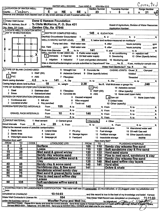
Specific Water Well Detail |
|
|
| Location Info | |||
| Owner: Dane G. Hanson Foundation | Status: Constructed | ||
| Location: T3S, R21W, Sec. 23, E2 NE SE | County: Norton | ||
| Directions: | |||
| Latitude: 39.7755883 | Longitude: -99.6470771 | Datum NAD 27 | |
| Latitude: 39.7755955 | Longitude: -99.6474658 | Datum NAD 83 | |
| Longitude and latitude calculated by Survey from township-range-section-quarter calls. Only good to within the quarter call accuracy. | |||
| View well on interactive map | |||
| General Info | ||
| Well Depth: 145 ft. | Elevation: ft. | |
| Static Water Level: 66 ft. | Est. Yield: gpm. | |
| Comp. Date: 14-Oct-2003 | Well Use: Domestic | |
| DWR Applic. #: | Other ID: | |
| Driller Info | ||
| Driller: Woofter Pump & Well, Inc. | License #: 554 | |
| Scanned Form | View scan |
|
Chemical Sample Submitted?:
Water Well disinfected?: | ||
| Casing Info | ||
| Casing Type:
Casing Joints: |
Diam: in. to ft | |
| Casing height above land surface: in
Casing Weight: lbs/ft Wall thickness or gauge no.: | ||
| Screen and Perforation Info | ||
| Screen Type: | Screen Openings: | |
| Screen-perforated intervals | From: ft to ft | |
| Gravel pack intervals | From: ft to ft | |
| Grout Info | ||
| Grout used: | From: to ft | |
| Source of Possible Contamination | ||
| Source: | ||
| Direction from well: | Distance: ft | |
| Lithologic Log
(Log data entered by KGS.) | ||
| From: 0 ft. to 3 ft. | surface | |
| From: 3 ft. to 15 ft. | loess | |
| From: 15 ft. to 29 ft. | medium sand and gravel with clay | |
| From: 29 ft. to 33 ft. | sandy clay with some sand | |
| From: 33 ft. to 40 ft. | soft sandstone with fine sand and clay | |
| From: 40 ft. to 48 ft. | sandy clay and some sand | |
| From: 48 ft. to 52 ft. | sandstone and clay and fine sand | |
| From: 52 ft. to 60 ft. | sandstone with medium sandy clay | |
| From: 60 ft. to 75 ft. | medium sand and gravel, fairly loose | |
| From: 75 ft. to 90 ft. | fine to medium sand with fine clay lenses | |
| From: 90 ft. to 105 ft. | soft sandstone with fine sand and clay | |
| From: 105 ft. to 110 ft. | sandy clay with some fine sand | |
| From: 110 ft. to 120 ft. | soft sandstone clay and fine sand | |
| From: 120 ft. to 122 ft. | hard sandstone | |
| From: 122 ft. to 130 ft. | fine to medium sand, sandstone, and clay | |
| From: 130 ft. to 135 ft. | sandy clay with some fine sand | |
| From: 135 ft. to 140 ft. | medium sand with fine clay layers | |
| From: 140 ft. to 141 ft. | hard flint | |
| From: 141 ft. to ft. | ochre and shale | |