|
|
|
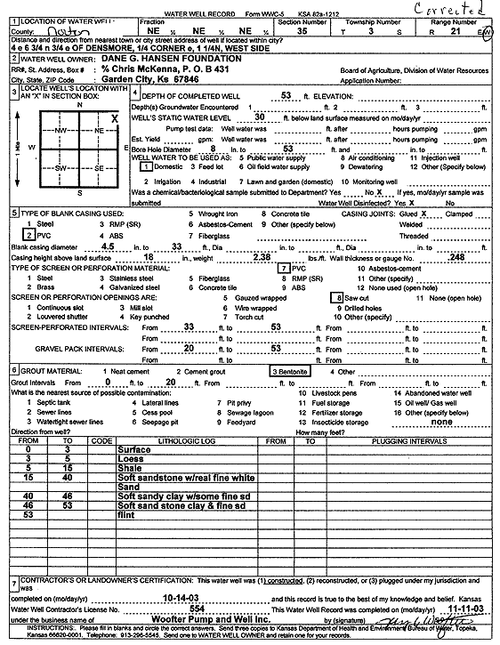
Specific Water Well Detail |
|
|
| Location Info | |||
| Owner: Dane G. Hansen Foundation | Status: Constructed | ||
| Location: T3S, R21W, Sec. 35, NE NE NE | County: Norton | ||
| Directions: from Densmore: 4 mi E, 6.75 mi N, 0.75 mi E, 0.25 E of corner, W side | |||
| Latitude: 39.7547403 | Longitude: -99.6475422 | Datum NAD 27 | |
| Latitude: 39.7547474 | Longitude: -99.647931 | Datum NAD 83 | |
| Longitude and latitude calculated by Survey from township-range-section-quarter calls. Only good to within the quarter call accuracy. | |||
| View well on interactive map | |||
| General Info | ||
| Well Depth: 53 ft. | Elevation: ft. | |
| Static Water Level: 30 ft. | Est. Yield: gpm. | |
| Comp. Date: 14-Oct-2003 | Well Use: Domestic | |
| DWR Applic. #: | Other ID: | |
| Driller Info | ||
| Driller: Woofter Pump & Well, Inc. | License #: 554 | |
| Scanned Form | View scan |
|
Chemical Sample Submitted?:
Water Well disinfected?: | ||
| Casing Info | ||
| Casing Type:
Casing Joints: |
Diam: in. to ft | |
| Casing height above land surface: in
Casing Weight: lbs/ft Wall thickness or gauge no.: | ||
| Screen and Perforation Info | ||
| Screen Type: | Screen Openings: | |
| Screen-perforated intervals | From: ft to ft | |
| Gravel pack intervals | From: ft to ft | |
| Grout Info | ||
| Grout used: | From: to ft | |
| Source of Possible Contamination | ||
| Source: | ||
| Direction from well: | Distance: ft | |
| Lithologic Log
(Log data entered by KGS.) | ||
| From: 0 ft. to 3 ft. | surface | |
| From: 3 ft. to 5 ft. | loess | |
| From: 5 ft. to 15 ft. | shale | |
| From: 15 ft. to 40 ft. | soft sandstone with real fine white sand | |
| From: 40 ft. to 46 ft. | soft sandy clay with some fine sand | |
| From: 46 ft. to 53 ft. | soft sandstone clay and fine sand | |
| From: 53 ft. to ft. | flint | |