|
|
|
Specific Water Well Detail |
|
|
| Location Info | |||
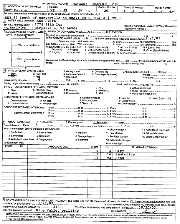
| Owner: Smith, John | Status: Plugged | ||
| Location: T3S, R7E, Sec. 26, NE SE SW | County: Marshall | ||
| Directions: from Marysville: Hwy 77 S to Quail Rd, 2 mi E, .25 mi N | |||
| Latitude: 39.7575925 | Longitude: -96.6106811 | Datum NAD 27 | |
| Latitude: 39.7575936 | Longitude: -96.6109766 | Datum NAD 83 | |
| Longitude and latitude calculated by Survey from township-range-section-quarter calls. Only good to within the quarter call accuracy. | |||
| View well on interactive map | |||
| General Info | ||
| Well Depth: 93 ft. | Elevation: ft. | |
| Static Water Level: 16 ft. | Est. Yield: gpm. | |
| Comp. Date: 01-Oct-2003 | Well Use: (unstated)/abandoned | |
| DWR Applic. #: | Other ID: | |
| Driller Info | ||
| Driller: Blue Valley Drilling | License #: 518 | |
| Scanned Form | View scan |
| Casing Info | ||
|
Casing Type:
Diam: in. Casing height above land surface: in | ||
| Grout Info | ||
| Grout used: | From: to ft | |
| Source of Possible Contamination | ||
| Source: | ||
| Direction from well: | Distance: ft | |