|
|
|
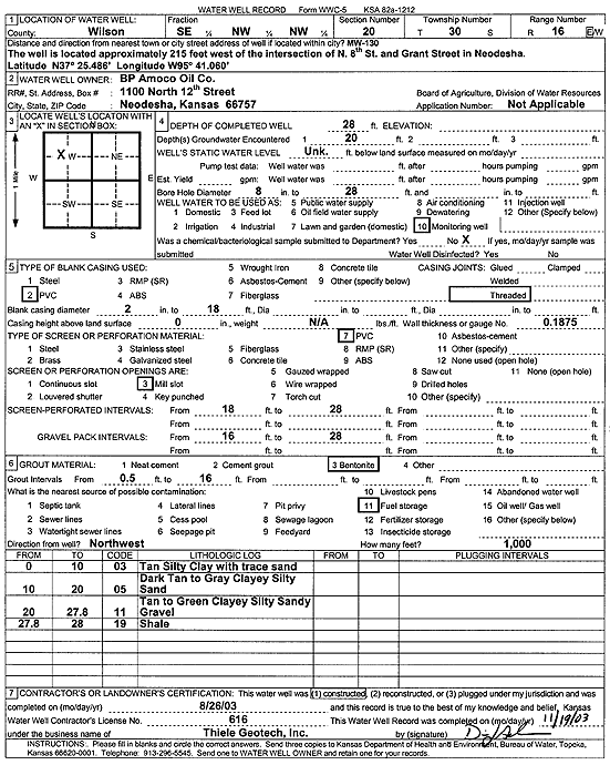
Specific Water Well Detail |
|
|
| Location Info | |||
| Owner: BP Amoco Oil Co. | Status: Constructed | ||
| Location: T30S, R16E, Sec. 20, SE NW NW | County: Wilson | ||
| Directions: from N 8th and Grant St, Neodesha: 215' W | |||
| Latitude: 37.4247038 | Longitude: -95.6840692 | Datum NAD 27 | |
| Latitude: 37.424766 | Longitude: -95.684333 | Datum NAD 83 | |
| Longitude and latitude from GPS measurements. | |||
| GPS Latitude: 37.424766 | GPS Longitude: -95.684333 | Datum NAD83 | |
| View well on interactive map | |||
| General Info | ||
| Well Depth: 28 ft. | Elevation: ft. | |
| Static Water Level: ft. | Est. Yield: gpm. | |
| Comp. Date: 26-Aug-2003 | Well Use: Monitoring well/observation/piezometer | |
| DWR Applic. #: | Other ID: MW 130 | |
| Driller Info | ||
| Driller: Thiele Geotech, Inc. | License #: 616 | |
| Scanned Form | View scan |
|
Chemical Sample Submitted?:
Water Well disinfected?: | ||
| Casing Info | ||
| Casing Type:
Casing Joints: |
Diam: in. to ft | |
| Casing height above land surface: in
Casing Weight: lbs/ft Wall thickness or gauge no.: | ||
| Screen and Perforation Info | ||
| Screen Type: | Screen Openings: | |
| Screen-perforated intervals | From: ft to ft | |
| Gravel pack intervals | From: ft to ft | |
| Grout Info | ||
| Grout used: | From: to ft | |
| Source of Possible Contamination | ||
| Source: | ||
| Direction from well: | Distance: ft | |
| Lithologic Log
(Log data entered by KGS.) | ||
| From: 0 ft. to 10 ft. | tan silty clay with trace sand | |
| From: 10 ft. to 20 ft. | dark tan to gray clayey silty sand | |
| From: 20 ft. to 27.8 ft. | tan to green clayey silty sandy gravel | |
| From: 27.8 ft. to 28 ft. | shale | |