|
|
|
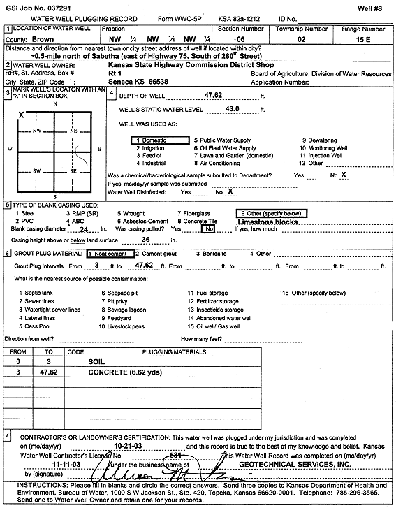
Specific Water Well Detail |
|
|
| Location Info | |||
| Owner: Kansas State Highway Commission District Shop | Status: Plugged | ||
| Location: T2S, R15E, Sec. 6, NW NW NW | County: Brown | ||
| Directions: from Sabetha: .5 mi N, E of Hwy 75, S of 280th St | |||
| Latitude: 39.9133661 | Longitude: -95.7867348 | Datum NAD 27 | |
| Latitude: 39.9133663 | Longitude: -95.7870012 | Datum NAD 83 | |
| Longitude and latitude calculated by Survey from township-range-section-quarter calls. Only good to within the quarter call accuracy. | |||
| View well on interactive map | |||
| General Info | ||
| Well Depth: 47.62 ft. | Elevation: ft. | |
| Static Water Level: 43 ft. | Est. Yield: gpm. | |
| Comp. Date: 21-Oct-2003 | Well Use: Domestic | |
| DWR Applic. #: | Other ID: Well 8 | |
| Driller Info | ||
| Driller: Geotechnical Services, Inc. | License #: 531 | |
| Scanned Form | View scan |
| Casing Info | ||
|
Casing Type:
Diam: in. Casing height above land surface: in | ||
| Grout Info | ||
| Grout used: | From: to ft | |
| Source of Possible Contamination | ||
| Source: | ||
| Direction from well: | Distance: ft | |