|
|
|
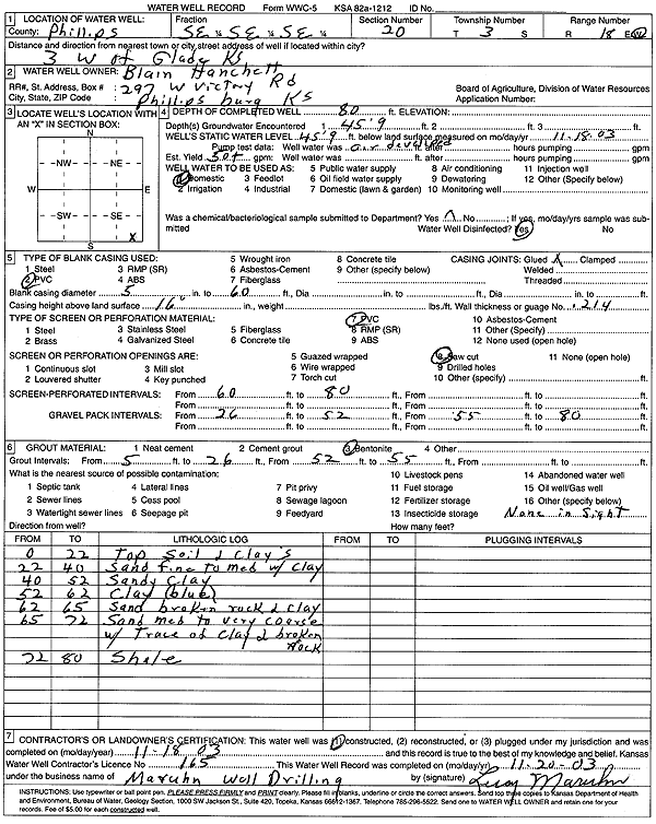
Specific Water Well Detail |
|
|
| Location Info | |||
| Owner: Hanchett, Blain | Status: Constructed | ||
| Location: T3S, R18W, Sec. 20, SE SE SE | County: Phillips | ||
| Directions: from Glade: 3 mi W | |||
| Latitude: 39.771122 | Longitude: -99.3664588 | Datum NAD 27 | |
| Latitude: 39.7711315 | Longitude: -99.3668349 | Datum NAD 83 | |
| Longitude and latitude calculated by Survey from township-range-section-quarter calls. Only good to within the quarter call accuracy. | |||
| View well on interactive map | |||
| General Info | ||
| Well Depth: 80 ft. | Elevation: ft. | |
| Static Water Level: 45.75 ft. | Est. Yield: 50 gpm. | |
| Comp. Date: 18-Nov-2003 | Well Use: Domestic | |
| DWR Applic. #: | Other ID: | |
| Driller Info | ||
| Driller: Leroy Maruhn Well Drilling, Inc. | License #: 165 | |
| Scanned Form | View scan |
|
Chemical Sample Submitted?:
Water Well disinfected?: | ||
| Casing Info | ||
| Casing Type:
Casing Joints: |
Diam: in. to ft | |
| Casing height above land surface: in
Casing Weight: lbs/ft Wall thickness or gauge no.: | ||
| Screen and Perforation Info | ||
| Screen Type: | Screen Openings: | |
| Screen-perforated intervals | From: ft to ft | |
| Gravel pack intervals | From: ft to ft | |
| Grout Info | ||
| Grout used: | From: to ft | |
| Source of Possible Contamination | ||
| Source: | ||
| Direction from well: | Distance: ft | |
| Lithologic Log
(Log data entered by KGS.) | ||
| From: 0 ft. to 22 ft. | topsoil and clays | |
| From: 22 ft. to 40 ft. | sand fine to medium with clay | |
| From: 40 ft. to 52 ft. | sandy clay | |
| From: 52 ft. to 62 ft. | clay, blue | |
| From: 62 ft. to 65 ft. | sand broken rock and clay | |
| From: 65 ft. to 72 ft. | sand medium to very coarse with trace of clay and broken rock | |
| From: 72 ft. to 80 ft. | shale | |