|
|
|
Specific Water Well Detail |
|
|
| Location Info | |||
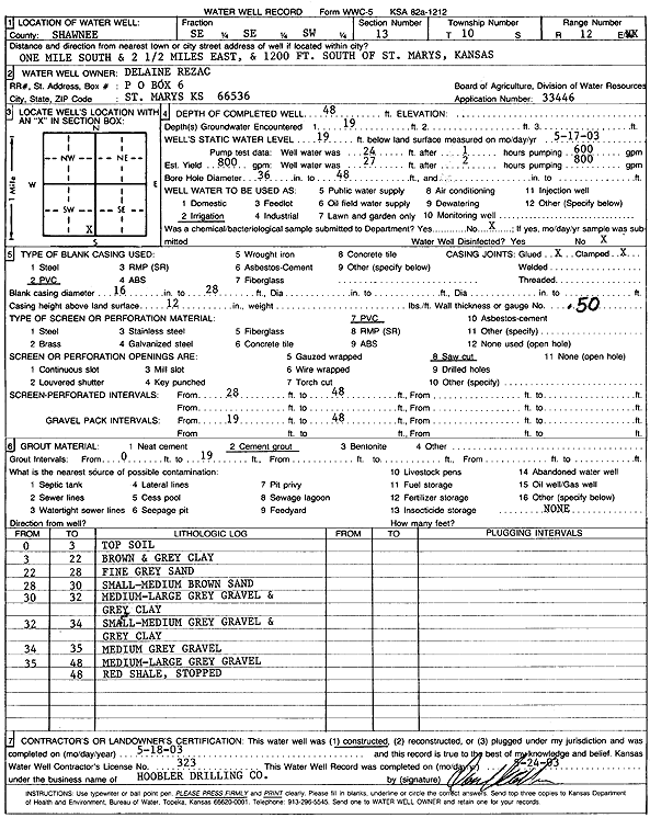
| Owner: Rezac, Delaine | Status: Constructed | ||
| Location: T10S, R12E, Sec. 13, SE SE SW | County: Shawnee | ||
| Directions: from St Mary's: 1 mi S, 2.5 mi E, 1200' S | |||
| Latitude: 39.1739978 | Longitude: -96.0273634 | Datum NAD 27 | |
| Latitude: 39.1739957 | Longitude: -96.0276332 | Datum NAD 83 | |
| Longitude and latitude calculated by Survey from township-range-section-quarter calls. Only good to within the quarter call accuracy. | |||
| View well on interactive map | |||
| General Info | ||
| Well Depth: 48 ft. | Elevation: ft. | |
| Static Water Level: 19 ft. | Est. Yield: 800 gpm. | |
| Comp. Date: 18-May-2003 | Well Use: Irrigation | |
| DWR Applic. #: 33446 | Other ID: | |
| Links | |
| No Wizard information available. | |
| View info from WIMAS Water Right Data base... | |
| Driller Info | ||
| Driller: Daniel H. Hoobler Drilling Co. | License #: 323 | |
| Scanned Form | View scan |
|
Chemical Sample Submitted?:
Water Well disinfected?: | ||
| Casing Info | ||
| Casing Type:
Casing Joints: |
Diam: in. to ft | |
| Casing height above land surface: in
Casing Weight: lbs/ft Wall thickness or gauge no.: | ||
| Screen and Perforation Info | ||
| Screen Type: | Screen Openings: | |
| Screen-perforated intervals | From: ft to ft | |
| Gravel pack intervals | From: ft to ft | |
| Grout Info | ||
| Grout used: | From: to ft | |
| Source of Possible Contamination | ||
| Source: | ||
| Direction from well: | Distance: ft | |
| Lithologic Log
(Log data entered by KGS.) | ||
| From: 0 ft. to 3 ft. | top soil | |
| From: 3 ft. to 22 ft. | brown and gray clay | |
| From: 22 ft. to 28 ft. | fine gray sand | |
| From: 28 ft. to 30 ft. | small-medium brown sand | |
| From: 30 ft. to 32 ft. | medium-large gray gravel and gray clay | |
| From: 32 ft. to 34 ft. | small-medium gray gravel and gray clay | |
| From: 34 ft. to 35 ft. | medium gray gravel | |
| From: 35 ft. to 48 ft. | medium-large gray gravel | |
| From: 48 ft. to ft. | red shale | |