|
|
|
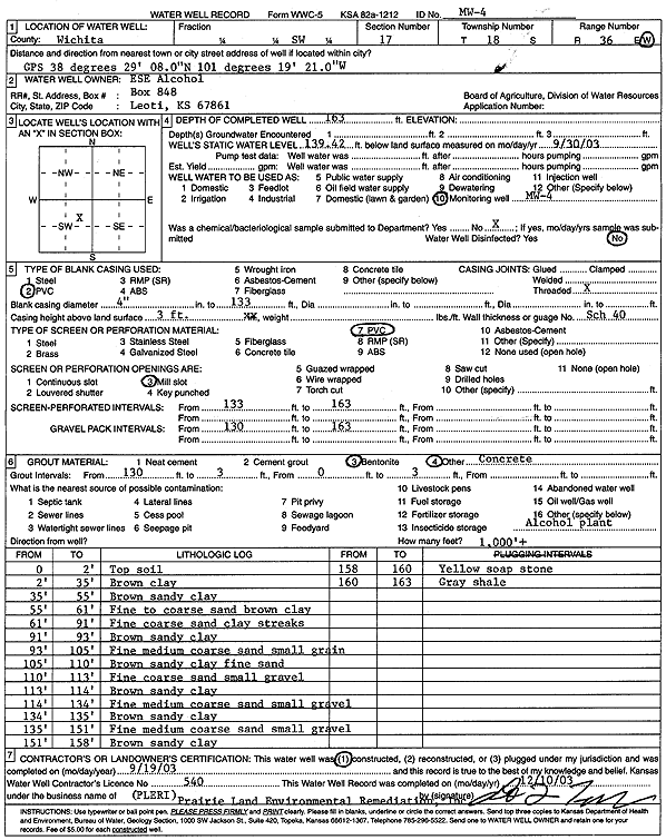
Specific Water Well Detail |
|
|
| Location Info | |||
| Owner: ESE Alcohol Plant | Status: Constructed | ||
| Location: T18S, R36W, Sec. 17, SW | County: Wichita | ||
| Directions: | |||
| Latitude: 38.4851877 | Longitude: -101.3259553 | Datum NAD 27 | |
| Latitude: 38.4852069 | Longitude: -101.3263921 | Datum NAD 83 | |
| Longitude and latitude calculated by Survey from township-range-section-quarter calls. Only good to within the quarter call accuracy. | |||
| View well on interactive map | |||
| General Info | ||
| Well Depth: 163 ft. | Elevation: ft. | |
| Static Water Level: 139.42 ft. | Est. Yield: gpm. | |
| Comp. Date: 19-Sep-2003 | Well Use: Monitoring well/observation/piezometer | |
| DWR Applic. #: | Other ID: MW 4 | |
| Driller Info | ||
| Driller: Prairie Land Environmental Remed. | License #: 540 | |
| Scanned Form | View scan |
|
Chemical Sample Submitted?:
Water Well disinfected?: | ||
| Casing Info | ||
| Casing Type:
Casing Joints: |
Diam: in. to ft | |
| Casing height above land surface: in
Casing Weight: lbs/ft Wall thickness or gauge no.: | ||
| Screen and Perforation Info | ||
| Screen Type: | Screen Openings: | |
| Screen-perforated intervals | From: ft to ft | |
| Gravel pack intervals | From: ft to ft | |
| Grout Info | ||
| Grout used: | From: to ft | |
| Source of Possible Contamination | ||
| Source: | ||
| Direction from well: | Distance: ft | |
| Lithologic Log
(Log data entered by KGS.) | ||
| From: 0 ft. to 2 ft. | Top soil | |
| From: 2 ft. to 35 ft. | Brown clay | |
| From: 35 ft. to 55 ft. | Brown sandy clay | |
| From: 55 ft. to 61 ft. | Fine to coarse sand, brown clay | |
| From: 61 ft. to 91 ft. | Fine to coarse sand, clay streaks | |
| From: 91 ft. to 93 ft. | Brown sandy clay | |
| From: 93 ft. to 105 ft. | Fine, medium, and coarse sand, small gravel | |
| From: 105 ft. to 110 ft. | Brown sandy clay, fine sand | |
| From: 110 ft. to 113 ft. | Fine to coarse sand, small gravel | |
| From: 113 ft. to 114 ft. | Brown sandy clay | |
| From: 114 ft. to 134 ft. | Fine, medium, and coarse sand, small gravel | |
| From: 134 ft. to 135 ft. | Brown sandy clay | |
| From: 135 ft. to 151 ft. | Fine, medium, and coarse sand, small gravel | |
| From: 151 ft. to 158 ft. | Brown sandy clay | |
| From: 158 ft. to 160 ft. | Yellow soapstone | |
| From: 160 ft. to 163 ft. | Gray shale | |