|
|
|
Specific Water Well Detail |
|
|
| Location Info | |||
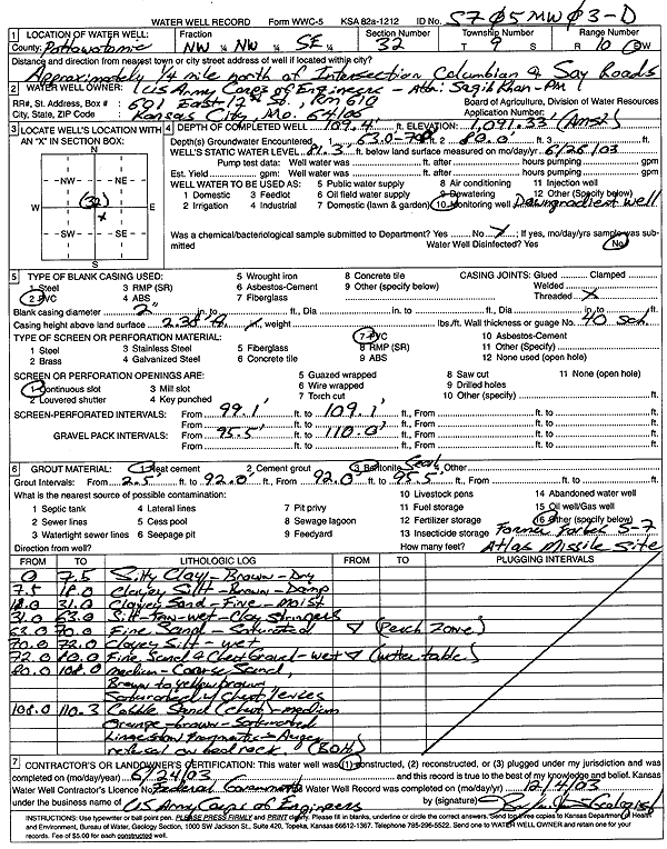
| Owner: U.S. Army Corps of Engineers | Status: Constructed | ||
| Location: T9S, R10E, Sec. 32, NW NW SE | County: Pottawatomie | ||
| Directions: from Columbian and Say Rds: .25 mi N of | |||
| Latitude: 39.2235646 | Longitude: -96.3230297 | Datum NAD 27 | |
| Latitude: 39.2235612 | Longitude: -96.3233057 | Datum NAD 83 | |
| Longitude and latitude calculated by Survey from township-range-section-quarter calls. Only good to within the quarter call accuracy. | |||
| View well on interactive map | |||
| General Info | ||
| Well Depth: 109.4 ft. | Elevation: 1091.33 ft. | |
| Static Water Level: 81.3 ft. | Est. Yield: gpm. | |
| Comp. Date: 24-Jun-2003 | Well Use: Monitoring well/observation/piezometer | |
| DWR Applic. #: | Other ID: MW 03D | |
| Driller Info | ||
| Driller: USACE | License #: | |
| Scanned Form | View scan |
|
Chemical Sample Submitted?:
Water Well disinfected?: | ||
| Casing Info | ||
| Casing Type:
Casing Joints: |
Diam: in. to ft | |
| Casing height above land surface: in
Casing Weight: lbs/ft Wall thickness or gauge no.: | ||
| Screen and Perforation Info | ||
| Screen Type: | Screen Openings: | |
| Screen-perforated intervals | From: ft to ft | |
| Gravel pack intervals | From: ft to ft | |
| Grout Info | ||
| Grout used: | From: to ft | |
| Source of Possible Contamination | ||
| Source: | ||
| Direction from well: | Distance: ft | |
| Lithologic Log
(Log data entered by KGS.) | ||
| From: 0 ft. to 7.5 ft. | silty clay, brown, dry | |
| From: 7.5 ft. to 18 ft. | clayey silt, brown, damp | |
| From: 18 ft. to 31 ft. | clayey fine sand, moist | |
| From: 31 ft. to 63 ft. | silt, tan, wet, with clay stringer | |
| From: 63 ft. to 70 ft. | fine sand, saturated | |
| From: 70 ft. to 72 ft. | clayey silt, wet | |
| From: 72 ft. to 80 ft. | fine sand and chert gravel, wet | |
| From: 80 ft. to 108 ft. | medium-coarse sand, brown to yellow brown, saturated, with chert lenses | |
| From: 108 ft. to 110.3 ft. | cobble sand (chert), medium orange brown, saturated, limestone fragments | |
| From: 110.3 ft. to ft. | bedrock | |