|
|
|
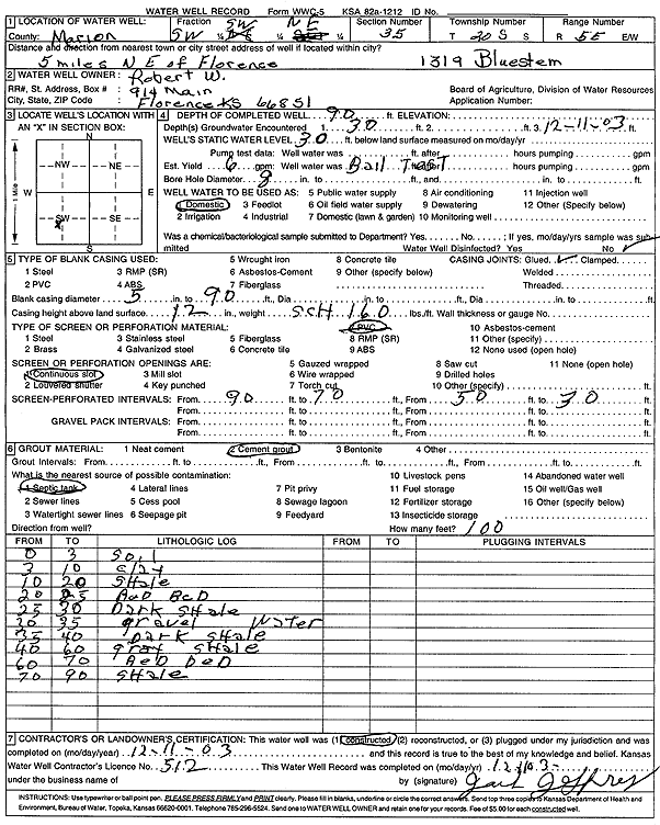
Specific Water Well Detail |
|
|
| Location Info | |||
| Owner: Robert W. | Status: Constructed | ||
| Location: T20S, R5E, Sec. 35, SW SW NE | County: Marion | ||
| Directions: 1319 Bluestem - from Florence: 5 mi NE | |||
| Latitude: 38.2694255 | Longitude: -96.8453995 | Datum NAD 27 | |
| Latitude: 38.2694424 | Longitude: -96.8456966 | Datum NAD 83 | |
| Longitude and latitude calculated by Survey from township-range-section-quarter calls. Only good to within the quarter call accuracy. | |||
| View well on interactive map | |||
| General Info | ||
| Well Depth: 90 ft. | Elevation: ft. | |
| Static Water Level: 30 ft. | Est. Yield: 6 gpm. | |
| Comp. Date: 11-Dec-2003 | Well Use: Domestic | |
| DWR Applic. #: | Other ID: | |
| Driller Info | ||
| Driller: Jack B. Jeffrey Well Drilling | License #: 512 | |
| Scanned Form | View scan |
|
Chemical Sample Submitted?:
Water Well disinfected?: | ||
| Casing Info | ||
| Casing Type:
Casing Joints: |
Diam: in. to ft | |
| Casing height above land surface: in
Casing Weight: lbs/ft Wall thickness or gauge no.: | ||
| Screen and Perforation Info | ||
| Screen Type: | Screen Openings: | |
| Screen-perforated intervals | From: ft to ft | |
| Gravel pack intervals | From: ft to ft | |
| Grout Info | ||
| Grout used: | From: to ft | |
| Source of Possible Contamination | ||
| Source: | ||
| Direction from well: | Distance: ft | |
| Lithologic Log
(Log data entered by KGS.) | ||
| From: 0 ft. to 3 ft. | soil | |
| From: 3 ft. to 10 ft. | clay | |
| From: 10 ft. to 20 ft. | shale | |
| From: 20 ft. to 25 ft. | red bed | |
| From: 25 ft. to 30 ft. | dark shale | |
| From: 30 ft. to 35 ft. | gravel | |
| From: 35 ft. to 40 ft. | dark shale | |
| From: 40 ft. to 60 ft. | gray shale | |
| From: 60 ft. to 70 ft. | red bed | |
| From: 70 ft. to 90 ft. | shale | |