|
|
|
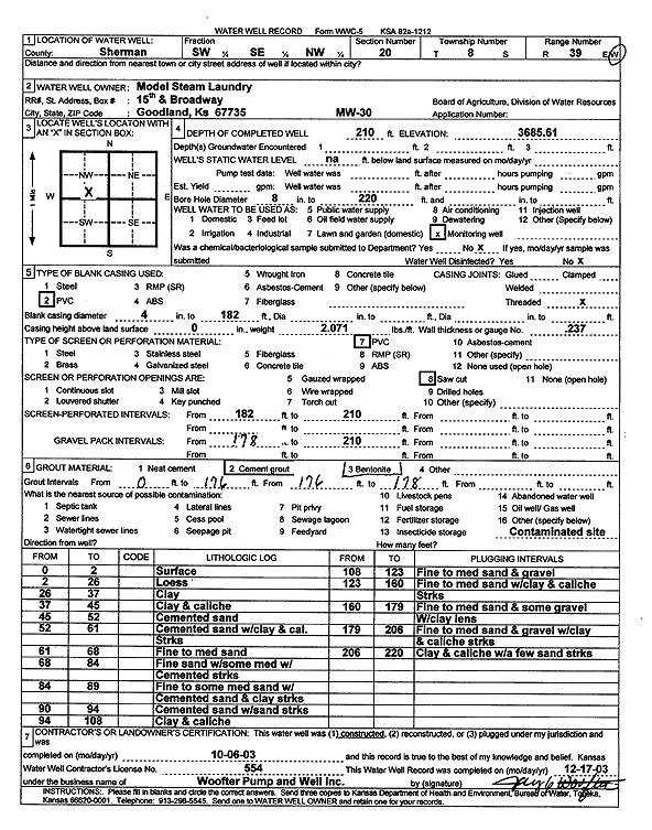
Specific Water Well Detail |
|
|
| Location Info | |||
| Owner: Model Steam Laundry | Status: Constructed | ||
| Location: T8S, R39W, Sec. 20, SW SE NW | County: Sherman | ||
| Directions: | |||
| Latitude: 39.3448695 | Longitude: -101.7010807 | Datum NAD 27 | |
| Latitude: 39.3448694 | Longitude: -101.7015304 | Datum NAD 83 | |
| Longitude and latitude calculated by Survey from township-range-section-quarter calls. Only good to within the quarter call accuracy. | |||
| View well on interactive map | |||
| General Info | ||
| Well Depth: 210 ft. | Elevation: 3685.61 ft. | |
| Static Water Level: ft. | Est. Yield: gpm. | |
| Comp. Date: 06-Oct-2003 | Well Use: Monitoring well/observation/piezometer | |
| DWR Applic. #: | Other ID: MW 30 | |
| Driller Info | ||
| Driller: Jay C. Woofter Pump & Well, Inc. | License #: 554 | |
| Scanned Form | View scan |
|
Chemical Sample Submitted?:
Water Well disinfected?: | ||
| Casing Info | ||
| Casing Type:
Casing Joints: |
Diam: in. to ft | |
| Casing height above land surface: in
Casing Weight: lbs/ft Wall thickness or gauge no.: | ||
| Screen and Perforation Info | ||
| Screen Type: | Screen Openings: | |
| Screen-perforated intervals | From: ft to ft | |
| Gravel pack intervals | From: ft to ft | |
| Grout Info | ||
| Grout used: | From: to ft | |
| Source of Possible Contamination | ||
| Source: | ||
| Direction from well: | Distance: ft | |
| Lithologic Log
(Log data entered by KGS.) | ||
| From: 0 ft. to 2 ft. | Surface | |
| From: 2 ft. to 26 ft. | Loess | |
| From: 26 ft. to 37 ft. | Clay | |
| From: 37 ft. to 45 ft. | Clay and caliche | |
| From: 45 ft. to 52 ft. | Cemented sand | |
| From: 52 ft. to 61 ft. | Cemented sand with clay and caliche streaks | |
| From: 61 ft. to 68 ft. | Fine to medium sand | |
| From: 68 ft. to 84 ft. | Fine sand with some medium with cemented streaks | |
| From: 84 ft. to 89 ft. | Fine to some medium sand with cemented sand and clay streaks | |
| From: 90 ft. to 94 ft. | Cemented sand with sand streaks | |
| From: 94 ft. to 108 ft. | Clay and caliche | |
| From: 108 ft. to 123 ft. | Fine to medium sand and gravel | |
| From: 123 ft. to 160 ft. | Fine to medium sand with clay and caliche streaks | |
| From: 160 ft. to 179 ft. | Fine to medium sand and some gravel with clay lens | |
| From: 179 ft. to 206 ft. | Fine to medium sand and gravel with clay lens | |
| From: 206 ft. to 220 ft. | Clay and caliche with a few sand streaks | |