|
|
|
Specific Water Well Detail |
|
|
| Location Info | |||
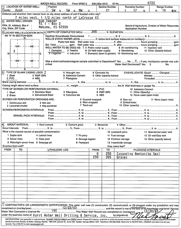
| Owner: Keener, Bob | Status: Plugged | ||
| Location: T17S, R19W, Sec. 21, SW SW NW | County: Rush | ||
| Directions: from La Crosse: 7 mi W, 1.5 mi N | |||
| Latitude: 38.5613668 | Longitude: -99.4371092 | Datum NAD 27 | |
| Latitude: 38.5613804 | Longitude: -99.4374962 | Datum NAD 83 | |
| Longitude and latitude calculated by Survey from township-range-section-quarter calls. Only good to within the quarter call accuracy. | |||
| View well on interactive map | |||
| General Info | ||
| Well Depth: 395 ft. | Elevation: ft. | |
| Static Water Level: ft. | Est. Yield: gpm. | |
| Comp. Date: 22-Dec-2003 | Well Use: Domestic | |
| DWR Applic. #: | Other ID: | |
| Driller Info | ||
| Driller: Melvin B. Karst Water Well Drilling & Service, Inc. | License #: 199 | |
| Scanned Form | View scan |
| Casing Info | ||
|
Casing Type:
Diam: in. Casing height above land surface: in | ||
| Grout Info | ||
| Grout used: | From: to ft | |
| Source of Possible Contamination | ||
| Source: | ||
| Direction from well: | Distance: ft | |