|
|
|
Specific Water Well Detail |
|
|
| Location Info | |||
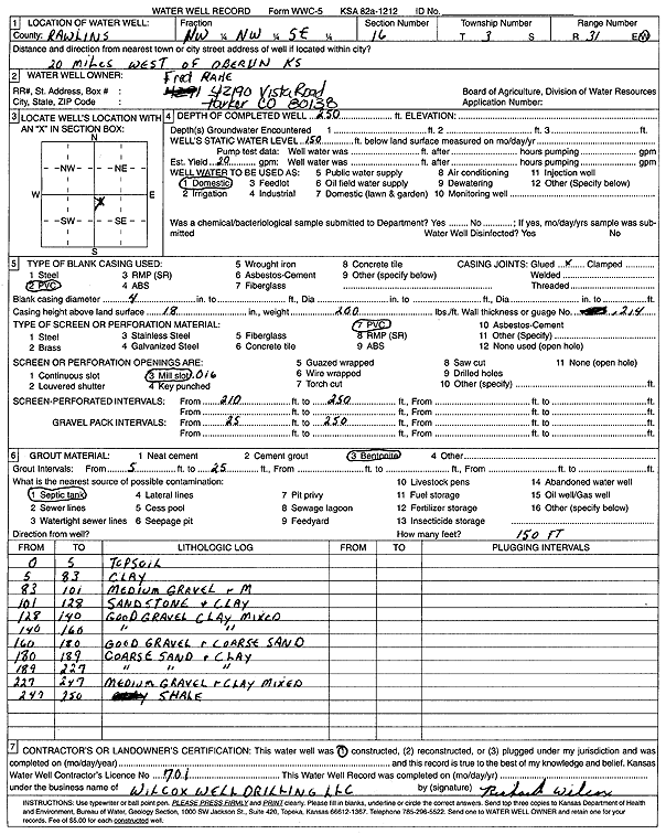
| Owner: Rahe, Fred | Status: Constructed | ||
| Location: T3S, R31W, Sec. 16, NW NW SE | County: Rawlins | ||
| Directions: from Oberlin: 20 mi W | |||
| Latitude: 39.791266 | Longitude: -100.8045616 | Datum NAD 27 | |
| Latitude: 39.7912696 | Longitude: -100.8049909 | Datum NAD 83 | |
| Longitude and latitude calculated by Survey from township-range-section-quarter calls. Only good to within the quarter call accuracy. | |||
| View well on interactive map | |||
| General Info | ||
| Well Depth: 250 ft. | Elevation: ft. | |
| Static Water Level: 150 ft. | Est. Yield: 20 gpm. | |
| Comp. Date: 01-Nov-2003 | Well Use: Domestic | |
| DWR Applic. #: | Other ID: | |
| Driller Info | ||
| Driller: Wilcox Well Drilling, LLC | License #: 701 | |
| Scanned Form | View scan |
|
Chemical Sample Submitted?:
Water Well disinfected?: | ||
| Casing Info | ||
| Casing Type:
Casing Joints: |
Diam: in. to ft | |
| Casing height above land surface: in
Casing Weight: lbs/ft Wall thickness or gauge no.: | ||
| Screen and Perforation Info | ||
| Screen Type: | Screen Openings: | |
| Screen-perforated intervals | From: ft to ft | |
| Gravel pack intervals | From: ft to ft | |
| Grout Info | ||
| Grout used: | From: to ft | |
| Source of Possible Contamination | ||
| Source: | ||
| Direction from well: | Distance: ft | |
| Lithologic Log
(Log data entered by KGS.) | ||
| From: 0 ft. to 5 ft. | top soil | |
| From: 5 ft. to 83 ft. | clay | |
| From: 83 ft. to 101 ft. | medium gravel | |
| From: 101 ft. to 128 ft. | sandstone and clay | |
| From: 128 ft. to 140 ft. | good gravel, clay, mixed | |
| From: 140 ft. to 160 ft. | good gravel, clay, mixed | |
| From: 160 ft. to 180 ft. | good gravel and coarse sand | |
| From: 180 ft. to 189 ft. | coarse sand and clay | |
| From: 189 ft. to 227 ft. | coarse sand and clay | |
| From: 227 ft. to 247 ft. | medium gravel and clay mixed | |
| From: 247 ft. to 250 ft. | shale | |