|
|
|
Specific Water Well Detail |
|
|
| Location Info | |||
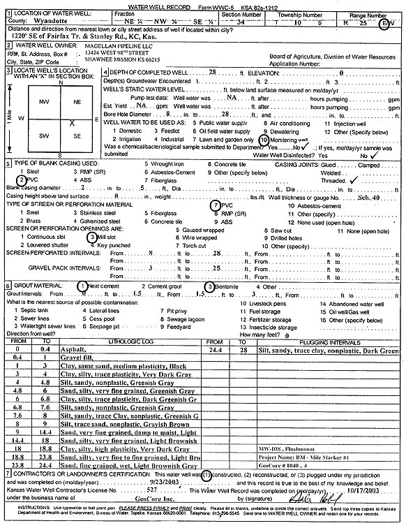
| Owner: Magellan Pipeline Company L.P. | Status: Constructed | ||
| Location: T10S, R25E, Sec. 34, NE NW SE | County: Wyandotte | ||
| Directions: from Fairfax Trafficway and Stanley Rd: 1220' SE, Kansas City | |||
| Latitude: 39.1352958 | Longitude: -94.6063635 | Datum NAD 27 | |
| Latitude: 39.1353 | Longitude: -94.6066 | Datum NAD 83 | |
| Longitude and latitude from GPS measurements. | |||
| GPS Latitude: 39.1353 | GPS Longitude: -94.6066 | Datum WGS84 | |
| View well on interactive map | |||
| General Info | ||
| Well Depth: 28 ft. | Elevation: ft. | |
| Static Water Level: ft. | Est. Yield: gpm. | |
| Comp. Date: 23-Sep-2003 | Well Use: Monitoring well/observation/piezometer | |
| DWR Applic. #: | Other ID: MW 10S | |
| Driller Info | ||
| Driller: GeoCore Services Inc. | License #: 527 | |
| Scanned Form | View scan |
|
Chemical Sample Submitted?:
Water Well disinfected?: | ||
| Casing Info | ||
| Casing Type:
Casing Joints: |
Diam: in. to ft | |
| Casing height above land surface: in
Casing Weight: lbs/ft Wall thickness or gauge no.: | ||
| Screen and Perforation Info | ||
| Screen Type: | Screen Openings: | |
| Screen-perforated intervals | From: ft to ft | |
| Gravel pack intervals | From: ft to ft | |
| Grout Info | ||
| Grout used: | From: to ft | |
| Source of Possible Contamination | ||
| Source: | ||
| Direction from well: | Distance: ft | |
| Lithologic Log
(Log data entered by KGS.) | ||
| From: 0 ft. to .4 ft. | asphalt | |
| From: .4 ft. to 1 ft. | gravel fill | |
| From: 1 ft. to 3 ft. | clay, some sand, medium plasticity, black | |
| From: 3 ft. to 4 ft. | silty clay, trace plasticity very dark gray | |
| From: 4 ft. to 4.8 ft. | silty, sandy, non plastic, greenish gray | |
| From: 4.8 ft. to 6 ft. | silty very fine sand, greenish gray | |
| From: 6 ft. to 6.8 ft. | silty clay, trace plasticity, dark greenish gray | |
| From: 6.8 ft. to 7.6 ft. | sandy silt, non plastic, greenish gray | |
| From: 7.6 ft. to 8 ft. | sandy silty with trace clay, non plastic, greenish gray | |
| From: 8 ft. to 9 ft. | silt, trace sand, non plastic, grayish brown | |
| From: 9 ft. to 14.4 ft. | very fine sand, damp to moist, light brownish gray | |
| From: 14.4 ft. to 18 ft. | very fine sand, silty, light brownish gray | |
| From: 18 ft. to 18.8 ft. | silty clay, high plasticity, very dark gray | |
| From: 18.8 ft. to 23.8 ft. | very fine to fine sand, silty, light brownish gray | |
| From: 23.8 ft. to 24.4 ft. | fine sand, wet, light brownish gray | |
| From: 24.4 ft. to 28 ft. | sandy silt, trace clay, non plastic, dark green | |