|
|
|
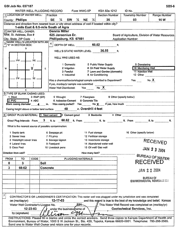
Specific Water Well Detail |
|
|
| Location Info | |||
| Owner: Miller, Dennis | Status: Plugged | ||
| Location: T3S, R16W, Sec. 35, SE SW NE | County: Phillips | ||
| Directions: from Agra: 1 mi E, .5 mi S | |||
| Latitude: 39.7501071 | Longitude: -99.0907226 | Datum NAD 27 | |
| Latitude: 39.7501182 | Longitude: -99.091087 | Datum NAD 83 | |
| Longitude and latitude calculated by Survey from township-range-section-quarter calls. Only good to within the quarter call accuracy. | |||
| View well on interactive map | |||
| General Info | ||
| Well Depth: 60.62 ft. | Elevation: ft. | |
| Static Water Level: 36.55 ft. | Est. Yield: gpm. | |
| Comp. Date: 17-Dec-2003 | Well Use: Monitoring well/observation/piezometer | |
| DWR Applic. #: | Other ID: SB 5-6 | |
| Driller Info | ||
| Driller: Geotechnical Services, Inc. | License #: 531 | |
| Scanned Form | View scan |
| Casing Info | ||
|
Casing Type:
Diam: in. Casing height above land surface: in | ||
| Grout Info | ||
| Grout used: | From: to ft | |
| Source of Possible Contamination | ||
| Source: | ||
| Direction from well: | Distance: ft | |