|
|
|
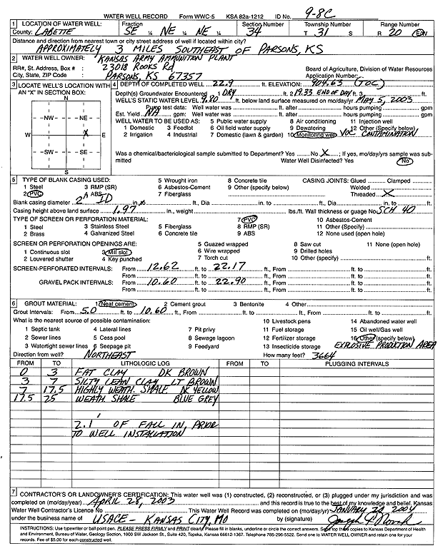
Specific Water Well Detail |
|
|
| Location Info | |||
| Owner: Kansas Army Ammunition Plant | Status: Constructed | ||
| Location: T31S, R20E, Sec. 34, SE NE NE | County: Labette | ||
| Directions: from Parsons: 3 mi SE | |||
| Latitude: 37.3079363 | Longitude: -95.1951933 | Datum NAD 27 | |
| Latitude: 37.3079974 | Longitude: -95.1954412 | Datum NAD 83 | |
| Longitude and latitude calculated by Survey from township-range-section-quarter calls. Only good to within the quarter call accuracy. | |||
| View well on interactive map | |||
| General Info | ||
| Well Depth: 22.9 ft. | Elevation: 904.63 ft. | |
| Static Water Level: 9.8 ft. | Est. Yield: gpm. | |
| Comp. Date: 28-Apr-2003 | Well Use: Monitoring well/observation/piezometer | |
| DWR Applic. #: | Other ID: 9-8 C | |
| Driller Info | ||
| Driller: USACE | License #: | |
| Scanned Form | View scan |
|
Chemical Sample Submitted?:
Water Well disinfected?: | ||
| Casing Info | ||
| Casing Type:
Casing Joints: |
Diam: in. to ft | |
| Casing height above land surface: in
Casing Weight: lbs/ft Wall thickness or gauge no.: | ||
| Screen and Perforation Info | ||
| Screen Type: | Screen Openings: | |
| Screen-perforated intervals | From: ft to ft | |
| Gravel pack intervals | From: ft to ft | |
| Grout Info | ||
| Grout used: | From: to ft | |
| Source of Possible Contamination | ||
| Source: | ||
| Direction from well: | Distance: ft | |
| Lithologic Log
(Log data entered by KGS.) | ||
| From: 0 ft. to 3 ft. | fat clay, dark brown | |
| From: 3 ft. to 7 ft. | silty lean clay, light brown | |
| From: 7 ft. to 17.5 ft. | highly weathered shale, dark yellow | |
| From: 17.5 ft. to 25 ft. | weathered shale, blue gray | |