|
|
|
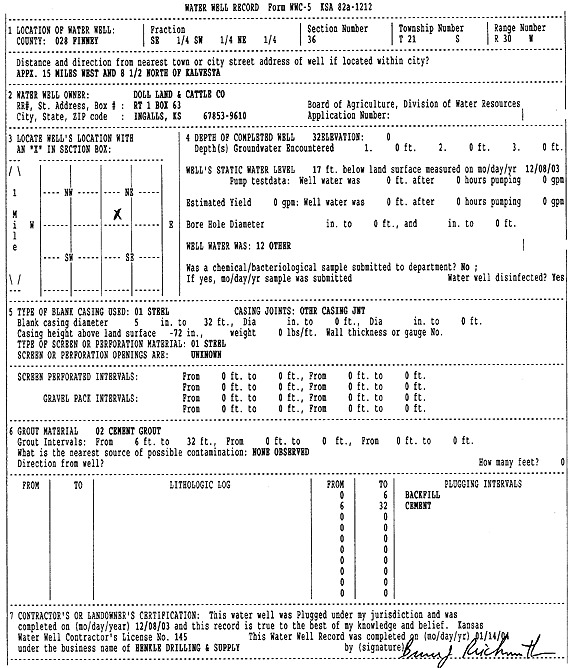
Specific Water Well Detail |
|
|
| Location Info | |||
| Owner: Doll Land and Cattle Co. | Status: Plugged | ||
| Location: T21S, R30W, Sec. 36, SE SW NE | County: Finney | ||
| Directions: from Kalvesta: 15 mi W and 8.5 mi N | |||
| Latitude: 38.1845058 | Longitude: -100.5600871 | Datum NAD 27 | |
| Latitude: 38.1845256 | Longitude: -100.5605121 | Datum NAD 83 | |
| Longitude and latitude calculated by Survey from township-range-section-quarter calls. Only good to within the quarter call accuracy. | |||
| View well on interactive map | |||
| General Info | ||
| Well Depth: 32 ft. | Elevation: ft. | |
| Static Water Level: 17 ft. | Est. Yield: gpm. | |
| Comp. Date: 08-Dec-2003 | Well Use: Other | |
| DWR Applic. #: | Other ID: | |
| Driller Info | ||
| Driller: Richard Henkle Drilling & Supply Co. Inc. | License #: 145 | |
| Scanned Form | View scan |
| Casing Info | ||
|
Casing Type:
Diam: in. Casing height above land surface: in | ||
| Grout Info | ||
| Grout used: | From: to ft | |
| Source of Possible Contamination | ||
| Source: | ||
| Direction from well: | Distance: ft | |