|
|
|
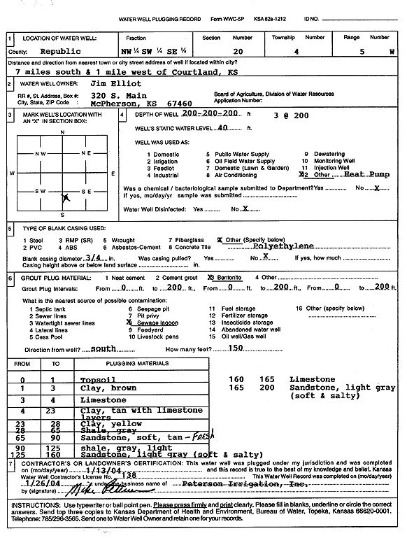
Specific Water Well Detail |
|
|
| Location Info | |||
| Owner: Elliot, Jim | Status: Constructed | ||
| Location: T4S, R5W, Sec. 20, NW SW SE | County: Republic | ||
| Directions: from Courtland: 7 mi S, 1 mi W (three 200-foot bores) | |||
| Latitude: 39.6855112 | Longitude: -97.9021825 | Datum NAD 27 | |
| Latitude: 39.6855182 | Longitude: -97.9025045 | Datum NAD 83 | |
| Longitude and latitude calculated by Survey from township-range-section-quarter calls. Only good to within the quarter call accuracy. | |||
| View well on interactive map | |||
| General Info | ||
| Well Depth: 200 ft. | Elevation: ft. | |
| Static Water Level: 40 ft. | Est. Yield: gpm. | |
| Comp. Date: 13-Jan-2004 | Well Use: Heat Pump (Closed Loop/Disposal), Geothermal | |
| DWR Applic. #: | Other ID: | |
| Driller Info | ||
| Driller: Michael Peterson Irrigation, Inc. | License #: 138 | |
| Scanned Form | View scan |
|
Chemical Sample Submitted?:
Water Well disinfected?: | ||
| Casing Info | ||
| Casing Type:
Casing Joints: |
Diam: in. to ft | |
| Casing height above land surface: in
Casing Weight: lbs/ft Wall thickness or gauge no.: | ||
| Screen and Perforation Info | ||
| Screen Type: | Screen Openings: | |
| Screen-perforated intervals | From: ft to ft | |
| Gravel pack intervals | From: ft to ft | |
| Grout Info | ||
| Grout used: | From: to ft | |
| Source of Possible Contamination | ||
| Source: | ||
| Direction from well: | Distance: ft | |
| Lithologic Log
(Log data entered by KGS.) | ||
| From: 0 ft. to 1 ft. | top soil | |
| From: 1 ft. to 3 ft. | clay, brown | |
| From: 3 ft. to 4 ft. | limestone | |
| From: 4 ft. to 23 ft. | clay, tan, with limestone layers | |
| From: 23 ft. to 28 ft. | clay, yellow | |
| From: 28 ft. to 65 ft. | shale, gray | |
| From: 65 ft. to 90 ft. | sandstone, soft, tan | |
| From: 90 ft. to 125 ft. | shale, light gray | |
| From: 125 ft. to 160 ft. | sandstone, light gray | |
| From: 160 ft. to 165 ft. | limestone | |
| From: 165 ft. to 200 ft. | sandstone, light gray | |