|
|
|
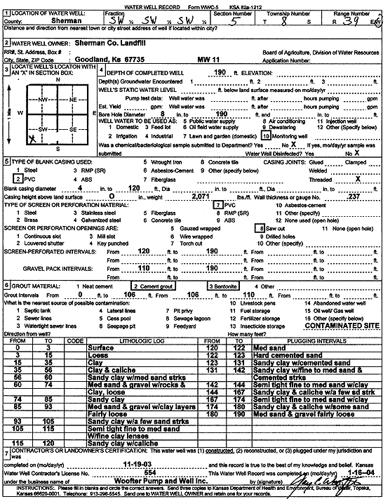
Specific Water Well Detail |
|
|
| Location Info | |||
| Owner: Sherman County Landfill | Status: Constructed | ||
| Location: T8S, R39W, Sec. 5, SW SW SW | County: Sherman | ||
| Directions: | |||
| Latitude: 39.3812291 | Longitude: -101.7060265 | Datum NAD 27 | |
| Latitude: 39.3812283 | Longitude: -101.7064765 | Datum NAD 83 | |
| Longitude and latitude calculated by Survey from township-range-section-quarter calls. Only good to within the quarter call accuracy. | |||
| View well on interactive map | |||
| General Info | ||
| Well Depth: 190 ft. | Elevation: ft. | |
| Static Water Level: ft. | Est. Yield: gpm. | |
| Comp. Date: 19-Nov-2003 | Well Use: Monitoring well/observation/piezometer | |
| DWR Applic. #: | Other ID: MW 11 | |
| Driller Info | ||
| Driller: Jay C. Woofter Pump & Well, Inc. | License #: 554 | |
| Scanned Form | View scan |
|
Chemical Sample Submitted?:
Water Well disinfected?: | ||
| Casing Info | ||
| Casing Type:
Casing Joints: |
Diam: in. to ft | |
| Casing height above land surface: in
Casing Weight: lbs/ft Wall thickness or gauge no.: | ||
| Screen and Perforation Info | ||
| Screen Type: | Screen Openings: | |
| Screen-perforated intervals | From: ft to ft | |
| Gravel pack intervals | From: ft to ft | |
| Grout Info | ||
| Grout used: | From: to ft | |
| Source of Possible Contamination | ||
| Source: | ||
| Direction from well: | Distance: ft | |
| Lithologic Log
(Log data entered by KGS.) | ||
| From: 0 ft. to 3 ft. | Surface | |
| From: 3 ft. to 15 ft. | Loess | |
| From: 15 ft. to 35 ft. | Clay | |
| From: 35 ft. to 56 ft. | Clay and caliche | |
| From: 56 ft. to 60 ft. | Sandy clay with medium sand streaks | |
| From: 60 ft. to 74 ft. | Medium sand and gravel with rocks and clay, loose | |
| From: 74 ft. to 85 ft. | Sandy clay | |
| From: 85 ft. to 93 ft. | Medium sand and gravel with clay layers, fairly loose | |
| From: 93 ft. to 105 ft. | Sandy clay with a few sand streaks | |
| From: 105 ft. to 115 ft. | Semi tight fine to medium sand with fine clay lenses | |
| From: 115 ft. to 120 ft. | Sandy clay with caliche | |
| From: 120 ft. to 122 ft. | Medium sand | |
| From: 122 ft. to 123 ft. | Hard cemented sand | |
| From: 123 ft. to 131 ft. | Sandy clay with cemented sand | |
| From: 131 ft. to 142 ft. | Sandy clay with fine to medium sand and cemented streaks | |
| From: 142 ft. to 144 ft. | Semi tight fine to medium sand with clay | |
| From: 144 ft. to 167 ft. | Sandy clay and caliche with a few sand streaks | |
| From: 167 ft. to 174 ft. | Semi tight fine to medium sand with clay | |
| From: 174 ft. to 180 ft. | Sandy clay and caliche with some sand | |
| From: 180 ft. to 190 ft. | Medium sand and gravel, fairly loose | |