|
|
|
Specific Water Well Detail |
|
|
| Location Info | |||
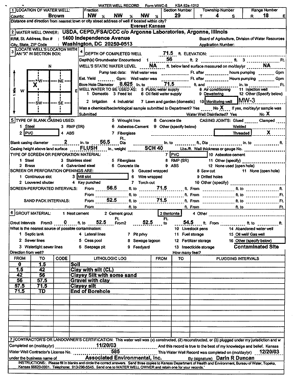
| Owner: U.S. Dept. of Agriculture | Status: Constructed | ||
| Location: T4S, R18E, Sec. 29, NW NW NW | County: Brown | ||
| Directions: Everest | |||
| Latitude: 39.6808843 | Longitude: -95.4325707 | Datum NAD 27 | |
| Latitude: 39.680886 | Longitude: -95.4328267 | Datum NAD 83 | |
| Longitude and latitude calculated by Survey from township-range-section-quarter calls. Only good to within the quarter call accuracy. | |||
| View well on interactive map | |||
| General Info | ||
| Well Depth: 71.5 ft. | Elevation: ft. | |
| Static Water Level: ft. | Est. Yield: gpm. | |
| Comp. Date: 20-Nov-2003 | Well Use: Monitoring well/observation/piezometer | |
| DWR Applic. #: | Other ID: MW 3 | |
| Driller Info | ||
| Driller: Associated Environmental, Inc. | License #: 585 | |
| Scanned Form | View scan |
|
Chemical Sample Submitted?:
Water Well disinfected?: | ||
| Casing Info | ||
| Casing Type:
Casing Joints: |
Diam: in. to ft | |
| Casing height above land surface: in
Casing Weight: lbs/ft Wall thickness or gauge no.: | ||
| Screen and Perforation Info | ||
| Screen Type: | Screen Openings: | |
| Screen-perforated intervals | From: ft to ft | |
| Gravel pack intervals | From: ft to ft | |
| Grout Info | ||
| Grout used: | From: to ft | |
| Source of Possible Contamination | ||
| Source: | ||
| Direction from well: | Distance: ft | |
| Lithologic Log
(Log data entered by KGS.) | ||
| From: 0 ft. to 1.5 ft. | soil | |
| From: 1.5 ft. to 42 ft. | clay with silt | |
| From: 42 ft. to 56 ft. | clayey silt with some sand | |
| From: 56 ft. to 57.5 ft. | gravel with clay | |
| From: 57.5 ft. to 71.5 ft. | clayey silt | |