|
|
|
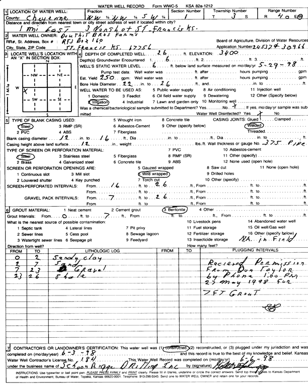
Specific Water Well Detail |
|
|
| Location Info | |||
| Owner: Douthit Brothers Farms | Status: Constructed | ||
| Location: T3S, R40W, Sec. 1, NW NW SW | County: Cheyenne | ||
| Directions: From St. Francis, 1 mile East, 3 miles North | |||
| Latitude: 39.8207563 | Longitude: -101.765614 | Datum NAD 27 | |
| Latitude: 39.8207491 | Longitude: -101.7660653 | Datum NAD 83 | |
| Longitude and latitude calculated by Survey from township-range-section-quarter calls. Only good to within the quarter call accuracy. | |||
| View well on interactive map | |||
| General Info | ||
| Well Depth: 26 ft. | Elevation: 3400 ft. | |
| Static Water Level: 6 ft. | Est. Yield: 250 gpm. | |
| Comp. Date: 03-Jun-1998 | Well Use: Irrigation | |
| DWR Applic. #: 24537, 30966 | Other ID: | |
| Links | |
| No Wizard information available. | |
| View info from WIMAS Water Right Data base... | |
| Driller Info | ||
| Driller: Schoenrogge Drilling, Inc. | License #: 184 | |
| Scanned Form | View scan |
|
Chemical Sample Submitted?:
Water Well disinfected?: | ||
| Casing Info | ||
| Casing Type:
Casing Joints: |
Diam: in. to ft | |
| Casing height above land surface: in
Casing Weight: lbs/ft Wall thickness or gauge no.: | ||
| Screen and Perforation Info | ||
| Screen Type: | Screen Openings: | |
| Screen-perforated intervals | From: ft to ft | |
| Gravel pack intervals | From: ft to ft | |
| Grout Info | ||
| Grout used: | From: to ft | |
| Source of Possible Contamination | ||
| Source: | ||
| Direction from well: | Distance: ft | |
| Lithologic Log
(Log data entered by KGS.) | ||
| From: 0 ft. to 2 ft. | Sandy clay | |
| From: 2 ft. to 7 ft. | Sand | |
| From: 7 ft. to 23 ft. | Gravel | |
| From: 23 ft. to 26 ft. | Shale | |