|
|
|
Specific Water Well Detail |
|
|
| Location Info | |||
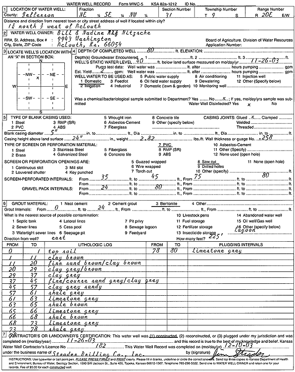
| Owner: Nitzsche, Bill and Nadine | Status: Constructed | ||
| Location: T9S, R20E, Sec. 31, NE SE NW | County: Jefferson | ||
| Directions: from McLouth: 1.25 mi N, .5 mi W | |||
| Latitude: 39.226265 | Longitude: -95.2277695 | Datum NAD 27 | |
| Latitude: 39.2262646 | Longitude: -95.2280176 | Datum NAD 83 | |
| Longitude and latitude calculated by Survey from township-range-section-quarter calls. Only good to within the quarter call accuracy. | |||
| View well on interactive map | |||
| General Info | ||
| Well Depth: 80 ft. | Elevation: ft. | |
| Static Water Level: 40 ft. | Est. Yield: 2 gpm. | |
| Comp. Date: 26-Nov-2003 | Well Use: Domestic | |
| DWR Applic. #: | Other ID: | |
| Driller Info | ||
| Driller: Strader Drilling Co., Inc. | License #: 182 | |
| Scanned Form | View scan |
|
Chemical Sample Submitted?:
Water Well disinfected?: | ||
| Casing Info | ||
| Casing Type:
Casing Joints: |
Diam: in. to ft | |
| Casing height above land surface: in
Casing Weight: lbs/ft Wall thickness or gauge no.: | ||
| Screen and Perforation Info | ||
| Screen Type: | Screen Openings: | |
| Screen-perforated intervals | From: ft to ft | |
| Gravel pack intervals | From: ft to ft | |
| Grout Info | ||
| Grout used: | From: to ft | |
| Source of Possible Contamination | ||
| Source: | ||
| Direction from well: | Distance: ft | |
| Lithologic Log
(Log data entered by KGS.) | ||
| From: 0 ft. to 1 ft. | top soil | |
| From: 1 ft. to 11 ft. | clay, brown | |
| From: 11 ft. to 20 ft. | fine brown sand with brown clay | |
| From: 20 ft. to 29 ft. | clay, gray-brown | |
| From: 29 ft. to 37 ft. | clay, gray | |
| From: 37 ft. to 45 ft. | fine-coarse gray sand and gray clay | |
| From: 45 ft. to 57 ft. | sandy clay, gray | |
| From: 57 ft. to 61 ft. | shale, gray | |
| From: 61 ft. to 63 ft. | limestone, gray | |
| From: 63 ft. to 65 ft. | shale, brown | |
| From: 65 ft. to 66 ft. | limestone, gray | |
| From: 66 ft. to 68 ft. | shale, brown | |
| From: 68 ft. to 73 ft. | limestone, gray | |
| From: 73 ft. to 78 ft. | shale, gray | |
| From: 78 ft. to 80 ft. | limestone, gray | |