|
|
|
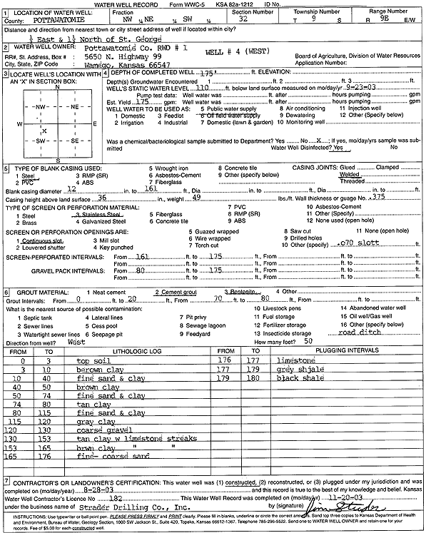
Specific Water Well Detail |
|
|
| Location Info | |||
| Owner: Pottawatomie Co. RWD 1 | Status: Constructed | ||
| Location: T9S, R9E, Sec. 32, NW NE SW | County: Pottawatomie | ||
| Directions: from St George: .5 mi E, 1.5 mi N (W well) | |||
| Latitude: 39.2243183 | Longitude: -96.439132 | Datum NAD 27 | |
| Latitude: 39.2243149 | Longitude: -96.4394099 | Datum NAD 83 | |
| Longitude and latitude calculated by Survey from township-range-section-quarter calls. Only good to within the quarter call accuracy. | |||
| View well on interactive map | |||
| General Info | ||
| Well Depth: 175 ft. | Elevation: ft. | |
| Static Water Level: 110 ft. | Est. Yield: 175 gpm. | |
| Comp. Date: 28-Aug-2003 | Well Use: Public Water Supply | |
| DWR Applic. #: | Other ID: Well 4 | |
| Links | |
| No Wizard information available. | |
| View info from WIMAS Water Right Data base... | |
| Driller Info | ||
| Driller: Strader Drilling Co., Inc. | License #: 182 | |
| Scanned Form | View scan |
|
Chemical Sample Submitted?:
Water Well disinfected?: | ||
| Casing Info | ||
| Casing Type:
Casing Joints: |
Diam: in. to ft | |
| Casing height above land surface: in
Casing Weight: lbs/ft Wall thickness or gauge no.: | ||
| Screen and Perforation Info | ||
| Screen Type: | Screen Openings: | |
| Screen-perforated intervals | From: ft to ft | |
| Gravel pack intervals | From: ft to ft | |
| Grout Info | ||
| Grout used: | From: to ft | |
| Source of Possible Contamination | ||
| Source: | ||
| Direction from well: | Distance: ft | |
| Lithologic Log
(Log data entered by KGS.) | ||
| From: 0 ft. to 3 ft. | top soil | |
| From: 3 ft. to 10 ft. | brown clay | |
| From: 10 ft. to 40 ft. | fine sand and clay | |
| From: 40 ft. to 50 ft. | brown clay | |
| From: 50 ft. to 74 ft. | fine sand and clay | |
| From: 74 ft. to 80 ft. | tan clay | |
| From: 80 ft. to 115 ft. | fine sand and clay | |
| From: 115 ft. to 120 ft. | gray clay | |
| From: 120 ft. to 130 ft. | coarse gravel | |
| From: 130 ft. to 153 ft. | tan clay with limestone streaks | |
| From: 153 ft. to 165 ft. | brown clay with limestone streaks | |
| From: 165 ft. to 176 ft. | fine-coarse sand | |
| From: 176 ft. to 177 ft. | limestone | |
| From: 177 ft. to 179 ft. | gray shale | |
| From: 179 ft. to 180 ft. | black shale | |