|
|
|
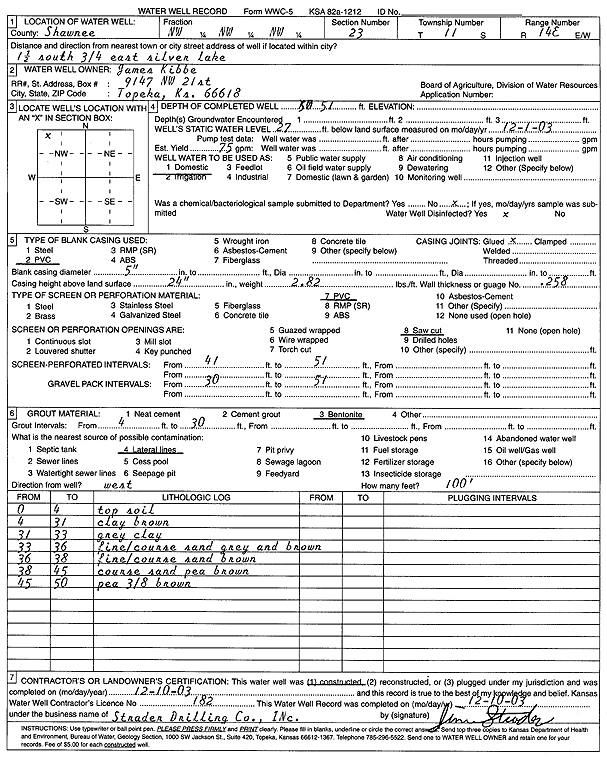
Specific Water Well Detail |
|
|
| Location Info | |||
| Owner: Kibbe, James | Status: Constructed | ||
| Location: T11S, R14E, Sec. 23, NW NW NW | County: Shawnee | ||
| Directions: from Silver Lake: 1.5 mi S, .75 mi E | |||
| Latitude: 39.0858614 | Longitude: -95.8338529 | Datum NAD 27 | |
| Latitude: 39.085861 | Longitude: -95.8341167 | Datum NAD 83 | |
| Longitude and latitude calculated by Survey from township-range-section-quarter calls. Only good to within the quarter call accuracy. | |||
| View well on interactive map | |||
| General Info | ||
| Well Depth: 51 ft. | Elevation: ft. | |
| Static Water Level: 27 ft. | Est. Yield: 75 gpm. | |
| Comp. Date: 10-Dec-2003 | Well Use: Domestic | |
| DWR Applic. #: | Other ID: | |
| Driller Info | ||
| Driller: Strader Drilling Co., Inc. | License #: 182 | |
| Scanned Form | View scan |
|
Chemical Sample Submitted?:
Water Well disinfected?: | ||
| Casing Info | ||
| Casing Type:
Casing Joints: |
Diam: in. to ft | |
| Casing height above land surface: in
Casing Weight: lbs/ft Wall thickness or gauge no.: | ||
| Screen and Perforation Info | ||
| Screen Type: | Screen Openings: | |
| Screen-perforated intervals | From: ft to ft | |
| Gravel pack intervals | From: ft to ft | |
| Grout Info | ||
| Grout used: | From: to ft | |
| Source of Possible Contamination | ||
| Source: | ||
| Direction from well: | Distance: ft | |
| Lithologic Log
(Log data entered by KGS.) | ||
| From: 0 ft. to 4 ft. | top soil | |
| From: 4 ft. to 31 ft. | clay, brown | |
| From: 31 ft. to 33 ft. | gray clay | |
| From: 33 ft. to 36 ft. | fine-coarse sand, gray and brown | |
| From: 36 ft. to 38 ft. | fine-coarse sand, brown | |
| From: 38 ft. to 45 ft. | coarse sand, pea gravel, brown | |
| From: 45 ft. to 50 ft. | pea, 3/8 gravel, brown | |