|
|
|
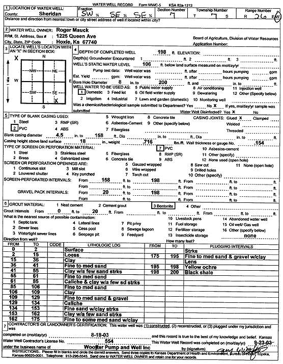
Specific Water Well Detail |
|
|
| Location Info | |||
| Owner: Mauck, Roger | Status: Constructed | ||
| Location: T7S, R26W, Sec. 7, SW SE SE | County: Sheridan | ||
| Directions: | |||
| Latitude: 39.4517594 | Longitude: -100.2590932 | Datum NAD 27 | |
| Latitude: 39.451763 | Longitude: -100.2595082 | Datum NAD 83 | |
| Longitude and latitude calculated by Survey from township-range-section-quarter calls. Only good to within the quarter call accuracy. | |||
| View well on interactive map | |||
| General Info | ||
| Well Depth: 198 ft. | Elevation: ft. | |
| Static Water Level: 106 ft. | Est. Yield: gpm. | |
| Comp. Date: 18-Aug-2003 | Well Use: Domestic | |
| DWR Applic. #: | Other ID: | |
| Driller Info | ||
| Driller: Jay C. Woofter Pump & Well, Inc. | License #: 554 | |
| Scanned Form | View scan |
|
Chemical Sample Submitted?:
Water Well disinfected?: | ||
| Casing Info | ||
| Casing Type:
Casing Joints: |
Diam: in. to ft | |
| Casing height above land surface: in
Casing Weight: lbs/ft Wall thickness or gauge no.: | ||
| Screen and Perforation Info | ||
| Screen Type: | Screen Openings: | |
| Screen-perforated intervals | From: ft to ft | |
| Gravel pack intervals | From: ft to ft | |
| Grout Info | ||
| Grout used: | From: to ft | |
| Source of Possible Contamination | ||
| Source: | ||
| Direction from well: | Distance: ft | |
| Lithologic Log
(Log data entered by KGS.) | ||
| From: 0 ft. to 2 ft. | Surface | |
| From: 2 ft. to 15 ft. | Loess | |
| From: 15 ft. to 36 ft. | Clay | |
| From: 36 ft. to 41 ft. | Fine to medium sand | |
| From: 41 ft. to 55 ft. | Clay with a few sand streaks | |
| From: 55 ft. to 61 ft. | Fine to medium sand | |
| From: 61 ft. to 85 ft. | Caliche and clay with a few sand streaks | |
| From: 85 ft. to 106 ft. | Fine to medium sand | |
| From: 106 ft. to 109 ft. | Clay | |
| From: 109 ft. to 129 ft. | Fine to medium sand and gravel | |
| From: 129 ft. to 134 ft. | Caliche | |
| From: 134 ft. to 153 ft. | Fine sand with clay streaks | |
| From: 153 ft. to 162 ft. | Clay with a few sand streaks | |
| From: 162 ft. to 175 ft. | Fine to some medium sand with clay streaks | |
| From: 175 ft. to 195 ft. | Fine to medium sand and gravel with clay lens | |
| From: 195 ft. to 198 ft. | Yellow ochre | |
| From: 198 ft. to 200 ft. | Black shale | |