|
|
|
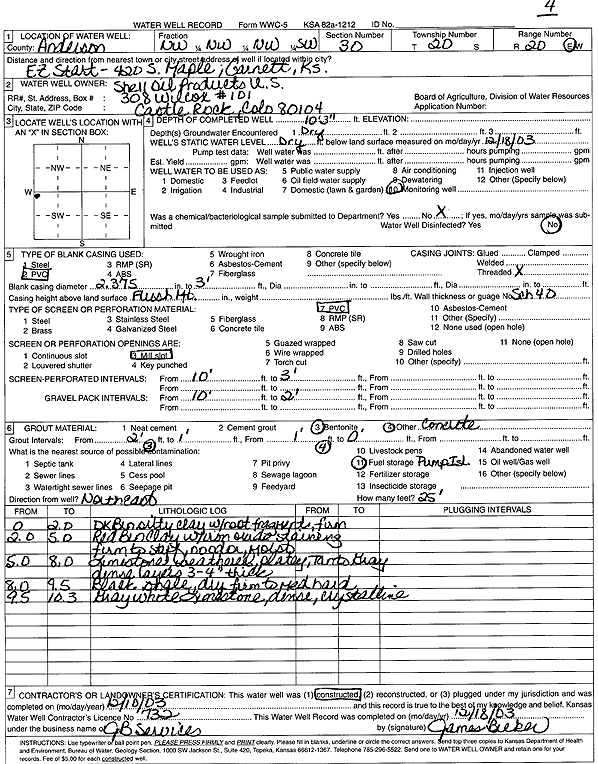
Specific Water Well Detail |
|
|
| Location Info | |||
| Owner: Shell Oil Products | Status: Constructed | ||
| Location: T20S, R20E, Sec. 30, NW NW NW SW | County: Anderson | ||
| Directions: 420 S Maple, EZ Start, Garnett | |||
| Latitude: 38.2805161 | Longitude: -95.2483918 | Datum NAD 27 | |
| Latitude: 38.2805377 | Longitude: -95.2486446 | Datum NAD 83 | |
| Longitude and latitude calculated by Survey from township-range-section-quarter calls. Only good to within the quarter call accuracy. | |||
| View well on interactive map | |||
| General Info | ||
| Well Depth: 10.25 ft. | Elevation: ft. | |
| Static Water Level: ft. | Est. Yield: gpm. | |
| Comp. Date: 10-Dec-2003 | Well Use: Monitoring well/observation/piezometer | |
| DWR Applic. #: | Other ID: MW 4 | |
| Driller Info | ||
| Driller: JB Environmental Service and Supply | License #: 732 | |
| Scanned Form | View scan |
|
Chemical Sample Submitted?:
Water Well disinfected?: | ||
| Casing Info | ||
| Casing Type:
Casing Joints: |
Diam: in. to ft | |
| Casing height above land surface: in
Casing Weight: lbs/ft Wall thickness or gauge no.: | ||
| Screen and Perforation Info | ||
| Screen Type: | Screen Openings: | |
| Screen-perforated intervals | From: ft to ft | |
| Gravel pack intervals | From: ft to ft | |
| Grout Info | ||
| Grout used: | From: to ft | |
| Source of Possible Contamination | ||
| Source: | ||
| Direction from well: | Distance: ft | |
| Lithologic Log
(Log data entered by KGS.) | ||
| From: 0 ft. to 2 ft. | Dark brown silty clay with root fragments, firm | |
| From: 2 ft. to 5 ft. | Red brown clay with iron oxide staining, firm to stiff, no odor, moist | |
| From: 5 ft. to 8 ft. | Limestone, weathered, platey, tan to gray, dense, layers 3-4 inches thick | |
| From: 9 ft. to 9.5 ft. | Black shale, dry, firm to medium hard | |
| From: 9.5 ft. to 10.3 ft. | Gray white limestone, dense, crystalline | |