|
|
|
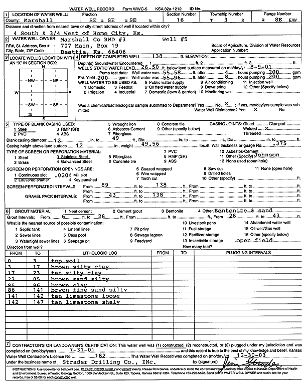
Specific Water Well Detail |
|
|
| Location Info | |||
| Owner: Marshall Co RWD 3 | Status: Constructed | ||
| Location: T3S, R8E, Sec. 16, SE SE SE | County: Marshall | ||
| Directions: from Home City: 4 mi S, .75 mi W | |||
| Latitude: 39.7846451 | Longitude: -96.5210321 | Datum NAD 27 | |
| Latitude: 39.7846459 | Longitude: -96.5213256 | Datum NAD 83 | |
| Longitude and latitude calculated by Survey from township-range-section-quarter calls. Only good to within the quarter call accuracy. | |||
| View well on interactive map | |||
| General Info | ||
| Well Depth: 138 ft. | Elevation: ft. | |
| Static Water Level: 26.5 ft. | Est. Yield: 200 gpm. | |
| Comp. Date: 31-Jul-2001 | Well Use: Public Water Supply | |
| DWR Applic. #: | Other ID: well 5 | |
| Links | |
| No Wizard information available. | |
| View info from WIMAS Water Right Data base... | |
| Driller Info | ||
| Driller: Strader Drilling Co., Inc. | License #: 182 | |
| Scanned Form | View scan |
|
Chemical Sample Submitted?:
Water Well disinfected?: | ||
| Casing Info | ||
| Casing Type:
Casing Joints: |
Diam: in. to ft | |
| Casing height above land surface: in
Casing Weight: lbs/ft Wall thickness or gauge no.: | ||
| Screen and Perforation Info | ||
| Screen Type: | Screen Openings: | |
| Screen-perforated intervals | From: ft to ft | |
| Gravel pack intervals | From: ft to ft | |
| Grout Info | ||
| Grout used: | From: to ft | |
| Source of Possible Contamination | ||
| Source: | ||
| Direction from well: | Distance: ft | |
| Lithologic Log
(Log data entered by KGS.) | ||
| From: 0 ft. to 3 ft. | top soil | |
| From: 3 ft. to 17 ft. | brown silty clay | |
| From: 17 ft. to 23 ft. | tan silty clay | |
| From: 23 ft. to 85 ft. | brown silty sand | |
| From: 85 ft. to 86 ft. | brown clay | |
| From: 86 ft. to 141 ft. | brown fine silty sand | |
| From: 141 ft. to 142 ft. | tan limestone, loose | |
| From: 142 ft. to 147 ft. | tan shaley limestone | |