|
|
|
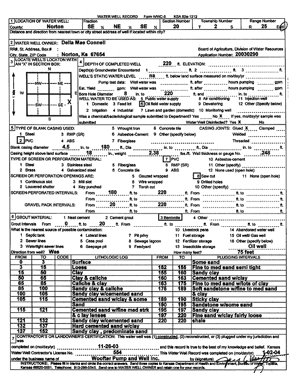
Specific Water Well Detail |
|
|
| Location Info | |||
| Owner: Connell, Della Mae | Status: Constructed | ||
| Location: T2S, R25W, Sec. 20, SE NE SE | County: Norton | ||
| Directions: | |||
| Latitude: 39.8609657 | Longitude: -100.1526191 | Datum NAD 27 | |
| Latitude: 39.8609708 | Longitude: -100.1530316 | Datum NAD 83 | |
| Longitude and latitude calculated by Survey from township-range-section-quarter calls. Only good to within the quarter call accuracy. | |||
| View well on interactive map | |||
| General Info | ||
| Well Depth: 220 ft. | Elevation: ft. | |
| Static Water Level: ft. | Est. Yield: gpm. | |
| Comp. Date: 26-Nov-2003 | Well Use: Oil Field Water Supply | |
| DWR Applic. #: 20030290 | Other ID: | |
| Links | |
| No Wizard information available. | |
| View info from WIMAS Water Right Data base... | |
| Driller Info | ||
| Driller: Jay C. Woofter Pump & Well, Inc. | License #: 554 | |
| Scanned Form | View scan |
|
Chemical Sample Submitted?:
Water Well disinfected?: | ||
| Casing Info | ||
| Casing Type:
Casing Joints: |
Diam: in. to ft | |
| Casing height above land surface: in
Casing Weight: lbs/ft Wall thickness or gauge no.: | ||
| Screen and Perforation Info | ||
| Screen Type: | Screen Openings: | |
| Screen-perforated intervals | From: ft to ft | |
| Gravel pack intervals | From: ft to ft | |
| Grout Info | ||
| Grout used: | From: to ft | |
| Source of Possible Contamination | ||
| Source: | ||
| Direction from well: | Distance: ft | |
| Lithologic Log
(Log data entered by KGS.) | ||
| From: 0 ft. to 3 ft. | surface | |
| From: 3 ft. to 15 ft. | loess | |
| From: 15 ft. to 50 ft. | clay | |
| From: 50 ft. to 65 ft. | clay and caliche | |
| From: 65 ft. to 85 ft. | caliche and clay | |
| From: 85 ft. to 100 ft. | sandy clay and caliche | |
| From: 100 ft. to 105 ft. | sandy clay with cemented sand | |
| From: 105 ft. to 115 ft. | cemented sand with clay and some sand | |
| From: 115 ft. to 121 ft. | cemented sand with fine medium streak and clay lenses | |
| From: 121 ft. to 132 ft. | sandy clay with cemented sand | |
| From: 132 ft. to 137 ft. | hard cemented sand with clay | |
| From: 137 ft. to 152 ft. | sandy clay, predominate sand some sand | |
| From: 152 ft. to 155 ft. | fine to medium sand semi tight | |
| From: 155 ft. to 160 ft. | sandy clay | |
| From: 160 ft. to 163 ft. | cemented sand with clay | |
| From: 163 ft. to 175 ft. | fine to medium sand with lots of clay | |
| From: 175 ft. to 189 ft. | soft sandstone with fine to medium sand and clay | |
| From: 189 ft. to 190 ft. | sticky clay | |
| From: 190 ft. to 195 ft. | sandstone with some sand | |
| From: 195 ft. to 197 ft. | sandy clay | |
| From: 197 ft. to 220 ft. | fine sand with clay fairly loose | |
| From: 220 ft. to 220 ft. | shale | |