|
|
|
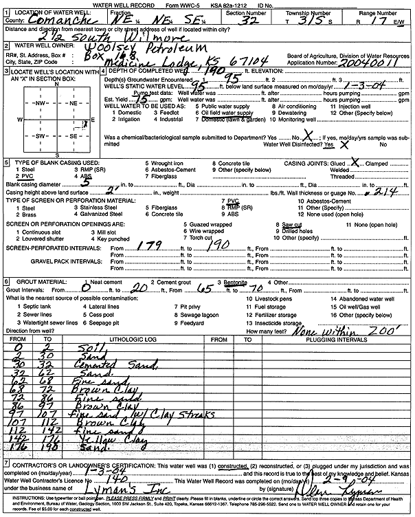
Specific Water Well Detail |
|
|
| Location Info | |||
| Owner: Woolsey Petroleum Corp. | Status: Constructed | ||
| Location: T31S, R17W, Sec. 32, NE NE SE | County: Comanche | ||
| Directions: from Wilmore: 2.5 mi S | |||
| Latitude: 37.302699 | Longitude: -99.1841165 | Datum NAD 27 | |
| Latitude: 37.3027227 | Longitude: -99.1845041 | Datum NAD 83 | |
| Longitude and latitude calculated by Survey from township-range-section-quarter calls. Only good to within the quarter call accuracy. | |||
| View well on interactive map | |||
| General Info | ||
| Well Depth: 190 ft. | Elevation: ft. | |
| Static Water Level: 95 ft. | Est. Yield: 75 gpm. | |
| Comp. Date: 03-Jan-2004 | Well Use: Oil Field Water Supply | |
| DWR Applic. #: 20040011 | Other ID: | |
| Links | |
| No Wizard information available. | |
| View info from WIMAS Water Right Data base... | |
| Driller Info | ||
| Driller: Dean L. Lyman, Inc. | License #: 140 | |
| Scanned Form | View scan |
|
Chemical Sample Submitted?:
Water Well disinfected?: | ||
| Casing Info | ||
| Casing Type:
Casing Joints: |
Diam: in. to ft | |
| Casing height above land surface: in
Casing Weight: lbs/ft Wall thickness or gauge no.: | ||
| Screen and Perforation Info | ||
| Screen Type: | Screen Openings: | |
| Screen-perforated intervals | From: ft to ft | |
| Gravel pack intervals | From: ft to ft | |
| Grout Info | ||
| Grout used: | From: to ft | |
| Source of Possible Contamination | ||
| Source: | ||
| Direction from well: | Distance: ft | |
| Lithologic Log
(Log data entered by KGS.) | ||
| From: 0 ft. to 2 ft. | soil | |
| From: 2 ft. to 30 ft. | sand | |
| From: 30 ft. to 32 ft. | cemented sand | |
| From: 32 ft. to 62 ft. | sand | |
| From: 62 ft. to 68 ft. | fine sand | |
| From: 68 ft. to 72 ft. | brown clay | |
| From: 72 ft. to 86 ft. | fine sand | |
| From: 86 ft. to 97 ft. | brown clay | |
| From: 97 ft. to 107 ft. | fine sand with clay streaks | |
| From: 107 ft. to 112 ft. | brown clay | |
| From: 112 ft. to 142 ft. | fine sand | |
| From: 142 ft. to 176 ft. | yellow clay | |
| From: 176 ft. to 198 ft. | sand | |