|
|
|
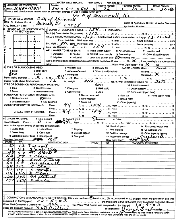
Specific Water Well Detail |
|
|
| Location Info | |||
| Owner: City of Grinnell | Status: Constructed | ||
| Location: T10S, R30W, Sec. 36, SW SW SW | County: Sheridan | ||
| Directions: from Grinnell: .25 mi N | |||
| Latitude: 39.1341526 | Longitude: -100.6266402 | Datum NAD 27 | |
| Latitude: 39.1341603 | Longitude: -100.6270605 | Datum NAD 83 | |
| Longitude and latitude calculated by Survey from township-range-section-quarter calls. Only good to within the quarter call accuracy. | |||
| View well on interactive map | |||
| General Info | ||
| Well Depth: 154 ft. | Elevation: ft. | |
| Static Water Level: 112 ft. | Est. Yield: 50 gpm. | |
| Comp. Date: 05-Dec-2003 | Well Use: Monitoring well/observation/piezometer | |
| DWR Applic. #: | Other ID: | |
| Driller Info | ||
| Driller: B & B Drilling | License #: 376 | |
| Scanned Form | View scan |
|
Chemical Sample Submitted?:
Water Well disinfected?: | ||
| Casing Info | ||
| Casing Type:
Casing Joints: |
Diam: in. to ft | |
| Casing height above land surface: in
Casing Weight: lbs/ft Wall thickness or gauge no.: | ||
| Screen and Perforation Info | ||
| Screen Type: | Screen Openings: | |
| Screen-perforated intervals | From: ft to ft | |
| Gravel pack intervals | From: ft to ft | |
| Grout Info | ||
| Grout used: | From: to ft | |
| Source of Possible Contamination | ||
| Source: | ||
| Direction from well: | Distance: ft | |
| Lithologic Log
(Log data entered by KGS.) | ||
| From: 0 ft. to 12 ft. | Top soil | |
| From: 12 ft. to 48 ft. | Sandy clay | |
| From: 48 ft. to 52 ft. | Medium sand | |
| From: 52 ft. to 58 ft. | S. clay | |
| From: 58 ft. to 60 ft. | Sand stone | |
| From: 60 ft. to 68 ft. | Medium gravel | |
| From: 68 ft. to 112 ft. | S. clay | |
| From: 112 ft. to 114 ft. | S. stone | |
| From: 114 ft. to 120 ft. | S. clay | |
| From: 120 ft. to 153 ft. | Medium gravel | |
| From: 153 ft. to 154 ft. | Shale | |