|
|
|
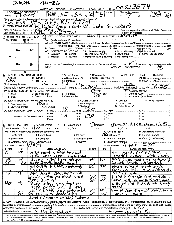
Specific Water Well Detail |
|
|
| Location Info | |||
| Owner: Hi Plains Coop | Status: Constructed | ||
| Location: T7S, R33W, Sec. 31, NE NE SW SE | County: Thomas | ||
| Directions: 485 E 4th, Colby (tag 00323574) | |||
| Latitude: 39.3974794 | Longitude: -101.041131 | Datum NAD 27 | |
| Latitude: 39.3974831 | Longitude: -101.0415637 | Datum NAD 83 | |
| Longitude and latitude calculated by Survey from township-range-section-quarter calls. Only good to within the quarter call accuracy. | |||
| View well on interactive map | |||
| General Info | ||
| Well Depth: 120.19 ft. | Elevation: 3139.87 ft. | |
| Static Water Level: ft. | Est. Yield: gpm. | |
| Comp. Date: 02-Dec-2003 | Well Use: Environmental Remediation, Air Sparge | |
| DWR Applic. #: | Other ID: ASP 6 | |
| Driller Info | ||
| Driller: Jay C. Woofter Pump & Well, Inc. | License #: 554 | |
| Scanned Form | View scan |
|
Chemical Sample Submitted?:
Water Well disinfected?: | ||
| Casing Info | ||
| Casing Type:
Casing Joints: |
Diam: in. to ft | |
| Casing height above land surface: in
Casing Weight: lbs/ft Wall thickness or gauge no.: | ||
| Screen and Perforation Info | ||
| Screen Type: | Screen Openings: | |
| Screen-perforated intervals | From: ft to ft | |
| Gravel pack intervals | From: ft to ft | |
| Grout Info | ||
| Grout used: | From: to ft | |
| Source of Possible Contamination | ||
| Source: | ||
| Direction from well: | Distance: ft | |
| Lithologic Log
(Log data entered by KGS.) | ||
| From: 0 ft. to 10 ft. | silty sand, very fine to medium with some gravel, light brown | |
| From: 10 ft. to 15 ft. | clayey silt, light brown | |
| From: 15 ft. to 25 ft. | very fine sandy clay, yellowish brown, fine to medium sand, well sorted | |
| From: 25 ft. to 40 ft. | very fine clayey sand, yellowish brown, moderately sorted | |
| From: 40 ft. to 45 ft. | very silty, very fine to very coarse sand and gravel, yellow brown, very poorly sorted | |
| From: 45 ft. to 60 ft. | gravel with some silty sand, very fine to coarse, subround to round, poorly sorted, reddish brown, with caliche | |
| From: 60 ft. to 65 ft. | very clayey sand, very fine to medium, reddish brown, well graded | |
| From: 65 ft. to 80 ft. | gravel with very fine to coarse sand, reddish brown, with caliche, poorly sorted | |
| From: 80 ft. to 85 ft. | very fine to very coarse sand with caliche | |
| From: 85 ft. to 100 ft. | gravel with very fine to very coarse sand with caliche, reddish brown, poorly sorted | |
| From: 100 ft. to 105 ft. | very coarse sand and gravel, reddish brown | |
| From: 105 ft. to 120 ft. | very coarse sand and gravel, reddish brown | |