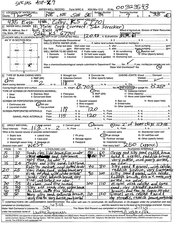
KGS Home Page Water Well Data base Specific Water Well Detail
Water Resources

Well T7S, R33W, Sec. 31, NE NE SW SE, Action: Constructed

Location Info
Owner: Hi Plains Coop Status: Constructed
Location: T7S, R33W, Sec. 31, NE NE SW SE County: Thomas
Directions: 485 E 4th, Colby (tag 00323543)
Latitude: 39.3974794 Longitude: -101.041131 Datum NAD 27
Latitude: 39.3974831 Longitude: -101.0415637 Datum NAD 83
Longitude and latitude calculated by Survey from township-range-section-quarter calls. Only good to within the quarter call accuracy.
View well on interactive map
General Info
Well Depth: 120.23 ft. Elevation: 3139.61 ft.
Static Water Level: ft. Est. Yield: gpm.
Comp. Date: 03-Dec-2003 Well Use: Environmental Remediation, Air Sparge
DWR Applic. #: Other ID: ASP 7
Driller Info
Driller: Jay C. Woofter Pump & Well, Inc. License #: 554
Scanned Form
View form(s) on screen Download scan(s)
The download files contain one or more TIFF images compressed into a ZIP archive. Your browser may be already set up to decompress these files. The TIFFs are 300 dpi archival-quality scans of the WWC5 forms and can be viewed by software like Adobe PhotoShop.
Chemical Sample Submitted?:
Water Well disinfected?:
Casing Info
Casing Type:
Casing Joints:
Diam: in. to ft
Casing height above land surface: in
Casing Weight: lbs/ft
Wall thickness or gauge no.:
Screen and Perforation Info
Screen Type: Screen Openings:
Screen-perforated intervals From: ft to ft
Gravel pack intervals From: ft to ft
Grout Info
Grout used: From: to ft
Source of Possible Contamination
Source:
Direction from well: Distance: ft
Lithologic Log
(Log data entered by KGS.)
From: 5 ft. to 10 ft. Sandy clay, light brown, fine, no odor
From: 10 ft. to 15 ft. Clayey sand, light brown, very fine, no odor
From: 15 ft. to 20 ft. Clayey and silty sand, light brown, fine to medium, mod. sorted, no odor
From: 20 ft. to 25 ft. Very clayey sand, yellow brown, very fine to medium with caliche streaks
From: 25 ft. to 30 ft. Sandy clay, yellowish brown, very fine, well sorted, no odor
From: 30 ft. to 35 ft. Sandy clay, sand fine to medium
From: 35 ft. to 40 ft. Silty and sandy clay, yellow brown
From: 40 ft. to 45 ft. Silty and sandy clay, more fine sand
From: 45 ft. to 50 ft. Very silty sand, yellowish brown, very fine to very coarse, poorly sorted
From: 50 ft. to 60 ft. Clayey and silty sand, reddish brown
From: 60 ft. to 70 ft. Sand and gravel, reddish brown, very coarse, mod. poorly sorted, no odor
From: 70 ft. to 80 ft. Silty sand and gravel, with caliche, reddish brown, very fine to coarse
From: 80 ft. to 100 ft. Silty sand and gravel, with caliche, reddish brown, fine to very coarse, poorly sorted, no odor
From: 100 ft. to 110 ft. Gravel with caliche and some sand, clay streaks, reddish brown, sand fine to coarse, no odor
From: 110 ft. to 120 ft. Gravel with caliche and sand and clay streaks, reddish brown, poorly sorted

Kansas Geological Survey
Comments to kgs-webadmin@ku.edu
URL=http://www.kgs.ku.edu/Magellan/WaterWell/index.html
Display Programs Updated January 2, 2025
Data added continuously.